Ixtapa night lights from space
Night Light of Ixtapa (Chiapas) from space (Mexico) Src. Average luminocity for 10x10km area is 4.9113% and for 50x50km: 15.575%.
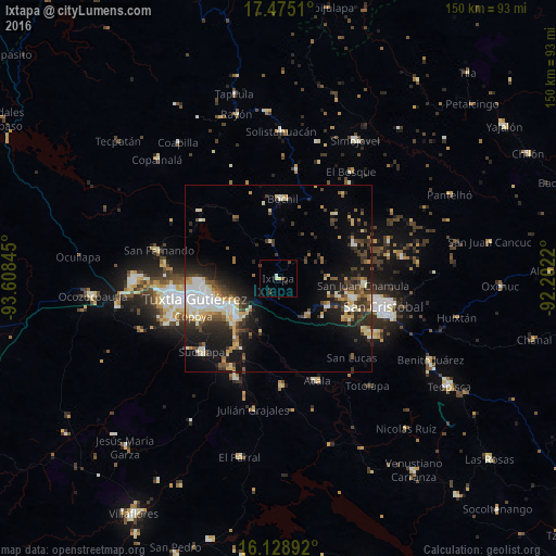
Analysis of Ixtapa night lights 2016
Square area 10x10 km:
 0%
0%90-99
1.52%80-89
0.43%70-79
0.65%60-69
0%50-59
1.08%40-49
0.87%30-39
1.08%20-29
1.73%10-19
0%0-9
92.64%Square area 50x50 km:
1.8%90-99
3.36%80-89
2.16%70-79
1.57%60-69
1.04%50-59
1.84%40-49
2.59%30-39
3.24%20-29
4.27%10-19
10.11%0-9
68.01%Clear (daylight) street map image can be seen on geolist.org.
Map coordinates:
17° 28' 30.4" North, 93° 36' 30.4" West
16° 48' 11.5" North, 92° 54' 19.2" West
16° 7' 44.1" North, 92° 12' 7.9" West
Some cities around Ixtapa sort by population:
• Tuxtla
22.6 km =14 mi,  257°
257°
• San Cristóbal de las Casas
29.2 km =18.1 mi,  105°
105°
• Chiapa de Corzo
15.5 km =9.6 mi,  226°
226°
• Suchiapa
28.7 km =17.8 mi, 226°
• Acala
29.5 km =18.3 mi,  158°
158°
• Bochil
21.5 km =13.4 mi,  3°
3°
• San Fernando
33.1 km =20.6 mi,  283°
283°
• Copoya
25.1 km =15.6 mi,  246°
246°
3526687 (p: 6,086)
Sources (retrieved 2019-11-25):
» Earth at Night: Flat Maps 2012, 2016