El Parral night lights from space
Night Light of El Parral (Chiapas) from space (Mexico) Src. Average luminocity for 10x10km area is 3.8678% and for 50x50km: 2.2027%.
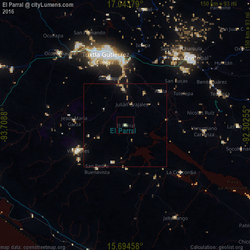
Analysis of El Parral night lights 2016
Square area 10x10 km:
 0%
0%90-99
1.24%80-89
0.41%70-79
1.65%60-69
0%50-59
0%40-49
0.83%30-39
0%20-29
0.83%10-19
0%0-9
95.04%Square area 50x50 km:
0.02%90-99
0.36%80-89
0.31%70-79
0.45%60-69
0.36%50-59
0.21%40-49
0.28%30-39
0.29%20-29
0.43%10-19
0.55%0-9
96.73%Clear (daylight) street map image can be seen on geolist.org.
Map coordinates:
17° 2' 37.6" North, 93° 42' 31.7" West
16° 22' 13.3" North, 93° 0' 20.4" West
15° 41' 40.5" North, 92° 18' 9.2" West
Some cities around El Parral sort by population:
• Chiapa de Corzo
37.5 km =23.3 mi,  358°
358°
• Villaflores
32.1 km =19.9 mi,  241°
241°
• Suchiapa
30.1 km =18.7 mi,  340°
340°
• Acala
29.8 km =18.5 mi,  46°
46°
• Villa Corzo
34.8 km =21.6 mi,  233°
233°
• San Pedro Buenavista
34 km =21.1 mi,  200°
200°
• Revolución Mexicana
23.4 km =14.5 mi, 198°
• Jesús María Garza
30.9 km =19.2 mi,  275°
275°
3816612 (p: 10,865)
Sources (retrieved 2019-11-25):
» Earth at Night: Flat Maps 2012, 2016