Nopalucán night lights from space
Night Light of Nopalucán (Puebla) from space (Mexico) Src. Average luminocity for 10x10km area is 24.6299% and for 50x50km: 16.7185%.
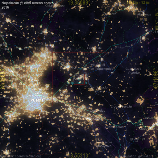
Analysis of Nopalucán night lights 2016
Square area 10x10 km:
 0.43%
0.43%90-99
2.6%80-89
5.41%70-79
3.9%60-69
3.03%50-59
1.08%40-49
4.55%30-39
2.6%20-29
4.33%10-19
40.04%0-9
32.03%Square area 50x50 km:
0.38%90-99
0.85%80-89
2.92%70-79
2.29%60-69
2.63%50-59
2%40-49
4.27%30-39
3.64%20-29
5.25%10-19
14.85%0-9
60.92%Clear (daylight) street map image can be seen on geolist.org.
Map coordinates:
19° 52' 51.6" North, 98° 31' 33.1" West
19° 13' 6.2" North, 97° 49' 21.8" West
18° 33' 11.3" North, 97° 7' 10.6" West
Some cities around Nopalucán sort by population:
• Grajales
2.3 km =1.4 mi,  62°
62°
• Cuapiaxtla
10.3 km =6.4 mi,  33°
33°
• Santa María Ixtiyucán
3.7 km =2.3 mi,  160°
160°
• Ignacio Zaragoza
13.2 km =8.2 mi,  308°
308°
• Ixtenco
8.3 km =5.2 mi,  296°
296°
• Zitlaltépec
9 km =5.6 mi,  259°
259°
• San José Xicohténcatl
15.1 km =9.4 mi,  356°
356°
• El Rincón Citlaltépetl
10.3 km =6.4 mi,  227°
227°
3522645 (p: 6,789)
Sources (retrieved 2019-11-25):
» Earth at Night: Flat Maps 2012, 2016