Santa María Ixtiyucán night lights from space
Night Light of Santa María Ixtiyucán (Puebla) from space (Mexico) Src. Average luminocity for 10x10km area is 18.3961% and for 50x50km: 17.3254%.
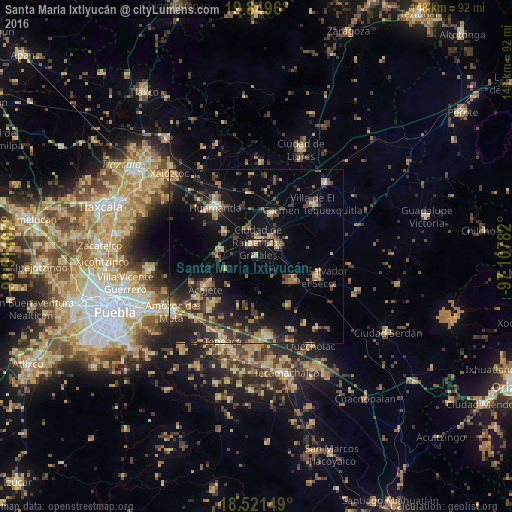
Analysis of Santa María Ixtiyucán night lights 2016
Square area 10x10 km:
 0.43%
0.43%90-99
1.73%80-89
5.19%70-79
2.81%60-69
1.95%50-59
0%40-49
2.6%30-39
3.25%20-29
2.6%10-19
23.59%0-9
55.84%Square area 50x50 km:
0.39%90-99
0.92%80-89
3%70-79
2.37%60-69
2.89%50-59
1.94%40-49
4.39%30-39
4%20-29
5.59%10-19
15.85%0-9
58.67%Clear (daylight) street map image can be seen on geolist.org.
Map coordinates:
19° 50' 58.6" North, 98° 30' 50.7" West
19° 11' 12.8" North, 97° 48' 39.4" West
18° 31' 17.4" North, 97° 6' 28.2" West
Some cities around Santa María Ixtiyucán sort by population:
• Grajales
4.6 km =2.9 mi,  10°
10°
• Cuapiaxtla
12.9 km =8 mi,  20°
20°
• Ignacio Zaragoza
16.5 km =10.3 mi,  315°
315°
• Nopalucán
3.7 km =2.3 mi,  340°
340°
• Ixtenco
11.3 km =7 mi,  309°
309°
• Soltepec
13 km =8.1 mi,  124°
124°
• Zitlaltépec
10.3 km =6.4 mi,  280°
280°
• El Rincón Citlaltépetl
9.4 km =5.8 mi,  248°
248°
3517246 (p: 7,298)
Sources (retrieved 2019-11-25):
» Earth at Night: Flat Maps 2012, 2016