Tekoh night lights from space
Night Light of Tekoh (Yucatán) from space (Mexico) Src. Average luminocity for 10x10km area is 4.7083% and for 50x50km: 11.883%.
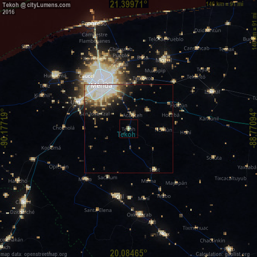
Analysis of Tekoh night lights 2016
Square area 10x10 km:
100  0%
0%
90-99 0.76%
80-89 0.76%
70-79 0.76%
60-69 0%
50-59 1.14%
40-49 0.95%
30-39 0.19%
20-29 0.95%
10-19 1.33%
0-9 93.18%
0%90-99
0.76%80-89
0.76%70-79
0.76%60-69
0%50-59
1.14%40-49
0.95%30-39
0.19%20-29
0.95%10-19
1.33%0-9
93.18%Square area 50x50 km:
100 2.68%
90-99 2.34%
80-89 2.07%
70-79 0.93%
60-69 1.21%
50-59 1.16%
40-49 2.03%
30-39 1.4%
20-29 1.74%
10-19 3.42%
0-9 81.03%
2.68%90-99
2.34%80-89
2.07%70-79
0.93%60-69
1.21%50-59
1.16%40-49
2.03%30-39
1.4%20-29
1.74%10-19
3.42%0-9
81.03%Clear (daylight) street map image can be seen on geolist.org.
Map coordinates:
21° 23' 59" North, 90° 10' 37.9" West
20° 44' 37" North, 89° 28' 26.6" West
20° 5' 4.7" North, 88° 46' 15.4" West
Some cities around Tekoh sort by population:
• Mérida
29.7 km =18.5 mi,  330°
330°
• Kanasín
23 km =14.3 mi,  337°
337°
• Tixkokob
29.9 km =18.6 mi,  15°
15°
• Acanceh
8 km =5 mi, 15°
• Tekit
27.5 km =17.1 mi,  147°
147°
• Seyé
14.8 km =9.2 mi,  46°
46°
• Homun
19.7 km =12.2 mi,  91°
91°
• Itzincab Palomeque
30.2 km =18.8 mi,  309°
309°
3516168 (p: 9,134)
Sources (retrieved 2019-11-25):
» Earth at Night: Flat Maps 2012, 2016