Santiago Tangamandapio night lights from space
Night Light of Santiago Tangamandapio (Michoacán) from space (Mexico) Src. Average luminocity for 10x10km area is 7.8355% and for 50x50km: 7.5548%.
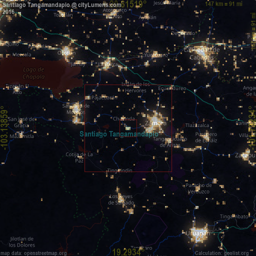
Analysis of Santiago Tangamandapio night lights 2016
Square area 10x10 km:
 0%
0%90-99
0.87%80-89
2.16%70-79
2.16%60-69
0%50-59
0.65%40-49
0.87%30-39
1.95%20-29
0.87%10-19
0.43%0-9
90.04%Square area 50x50 km:
0.19%90-99
0.74%80-89
1.75%70-79
1.21%60-69
0.74%50-59
0.69%40-49
1.92%30-39
1.48%20-29
1.56%10-19
5.08%0-9
84.66%Clear (daylight) street map image can be seen on geolist.org.
Map coordinates:
20° 36' 54.7" North, 103° 8' 18.9" West
19° 57' 20.4" North, 102° 26' 7.7" West
19° 17' 36.2" North, 101° 43' 56.4" West
Some cities around Santiago Tangamandapio sort by population:
• Zamora
16.2 km =10.1 mi,  78°
78°
• Jacona de Plancarte
13.3 km =8.3 mi,  91°
91°
• Tangancícuaro de Arista
25.1 km =15.6 mi,  107°
107°
• Pajacuarán
22.7 km =14.1 mi,  323°
323°
• Tarécuato
12.8 km =8 mi,  193°
193°
• Ario de Rayón
12.1 km =7.5 mi,  49°
49°
• Tingüindín
24.5 km =15.2 mi, 191°
• Chavinda
6.2 km =3.9 mi,  335°
335°
3983630 (p: 10,463)
Sources (retrieved 2019-11-25):
» Earth at Night: Flat Maps 2012, 2016