Ario de Rayón night lights from space
Night Light of Ario de Rayón (Michoacán) from space (Mexico) Src. Average luminocity for 10x10km area is 21.8532% and for 50x50km: 7.9878%.
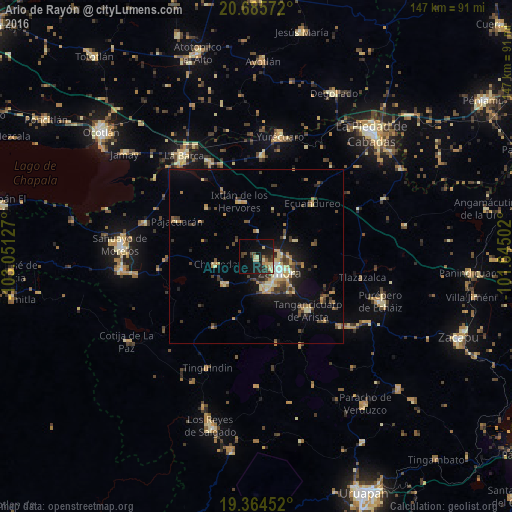
Analysis of Ario de Rayón night lights 2016
Square area 10x10 km:
 0%
0%90-99
2.58%80-89
5.75%70-79
1.98%60-69
1.59%50-59
1.98%40-49
3.77%30-39
3.97%20-29
10.12%10-19
24.01%0-9
44.25%Square area 50x50 km:
0.19%90-99
0.7%80-89
1.76%70-79
1.22%60-69
0.86%50-59
0.67%40-49
2.11%30-39
1.5%20-29
1.71%10-19
5.16%0-9
84.11%Clear (daylight) street map image can be seen on geolist.org.
Map coordinates:
20° 41' 8.6" North, 103° 3' 4.6" West
20° 1' 35.4" North, 102° 20' 53.3" West
19° 21' 52.3" North, 101° 38' 42.1" West
Some cities around Ario de Rayón sort by population:
• Zamora
8.1 km =5 mi,  124°
124°
• Jacona de Plancarte
9.3 km =5.8 mi,  152°
152°
• Tangancícuaro de Arista
21.4 km =13.3 mi,  136°
136°
• Santiago Tangamandapio
12.1 km =7.5 mi,  229°
229°
• Pajacuarán
25 km =15.5 mi,  294°
294°
• Tanhuato de Guerrero
28.9 km =18 mi,  3°
3°
• Tarécuato
23.7 km =14.7 mi,  210°
210°
• Chavinda
11.9 km =7.4 mi,  259°
259°
4018255 (p: 8,464)
Sources (retrieved 2019-11-25):
» Earth at Night: Flat Maps 2012, 2016