Tangancícuaro de Arista night lights from space
Night Light of Tangancícuaro de Arista (México) from space (Mexico) Src. Average luminocity for 10x10km area is 16.5541% and for 50x50km: 8.225%.
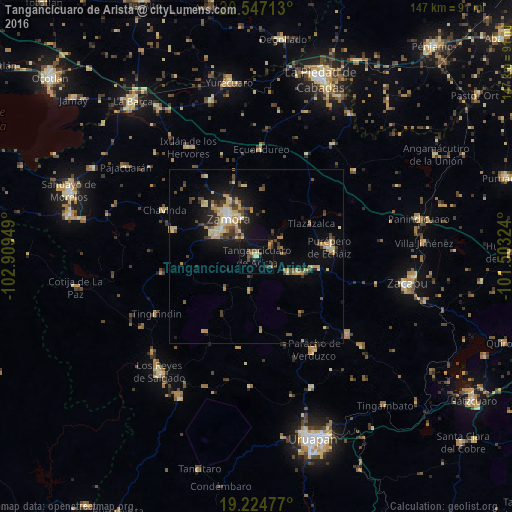
Analysis of Tangancícuaro de Arista night lights 2016
Square area 10x10 km:
 0%
0%90-99
0.87%80-89
2.6%70-79
2.16%60-69
2.38%50-59
1.52%40-49
6.49%30-39
2.81%20-29
1.95%10-19
12.12%0-9
67.1%Square area 50x50 km:
0.19%90-99
0.79%80-89
1.91%70-79
1.33%60-69
0.8%50-59
0.78%40-49
2.04%30-39
1.45%20-29
1.53%10-19
5.21%0-9
83.97%Clear (daylight) street map image can be seen on geolist.org.
Map coordinates:
20° 32' 49.7" North, 102° 54' 34.2" West
19° 53' 14.4" North, 102° 12' 22.9" West
19° 13' 29.2" North, 101° 30' 11.7" West
Some cities around Tangancícuaro de Arista sort by population:
• Zamora
13.6 km =8.5 mi,  323°
323°
• Jacona de Plancarte
12.8 km =8 mi,  304°
304°
• Purépero de Echáiz
21.1 km =13.1 mi,  83°
83°
• Santiago Tangamandapio
25.1 km =15.6 mi,  287°
287°
• Tarécuato
27.5 km =17.1 mi,  259°
259°
• Ario de Rayón
21.4 km =13.3 mi, 316°
• Chilchota
10.4 km =6.5 mi,  115°
115°
• Carapán
18 km =11.2 mi,  99°
99°
3982545 (p: 15,068)
Sources (retrieved 2019-11-25):
» Earth at Night: Flat Maps 2012, 2016