Tingüindín night lights from space
Night Light of Tingüindín (Michoacán) from space (Mexico) Src. Average luminocity for 10x10km area is 3.7562% and for 50x50km: 3.8552%.
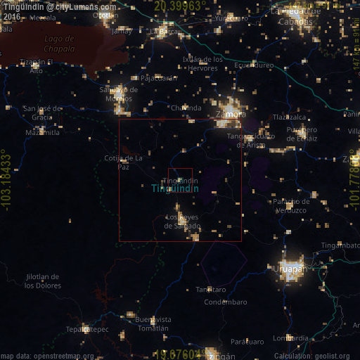
Analysis of Tingüindín night lights 2016
Square area 10x10 km:
 0%
0%90-99
0%80-89
0%70-79
1.03%60-69
1.45%50-59
1.45%40-49
0.62%30-39
0.41%20-29
0.83%10-19
0.83%0-9
93.39%Square area 50x50 km:
0%90-99
0.18%80-89
0.76%70-79
0.78%60-69
0.75%50-59
0.51%40-49
0.91%30-39
0.78%20-29
0.5%10-19
1.97%0-9
92.87%Clear (daylight) street map image can be seen on geolist.org.
Map coordinates:
20° 23' 58.7" North, 103° 11' 3.6" West
19° 44' 21.2" North, 102° 28' 52.3" West
19° 4' 33.7" North, 101° 46' 41.1" West
Some cities around Tingüindín sort by population:
• Jacona de Plancarte
29.8 km =18.5 mi,  37°
37°
• Los Reyes de Salgado
16.6 km =10.3 mi,  176°
176°
• Peribán de Ramos
25.4 km =15.8 mi,  163°
163°
• Cotija de la Paz
24.4 km =15.2 mi,  288°
288°
• Santiago Tangamandapio
24.5 km =15.2 mi,  11°
11°
• Tarécuato
11.7 km =7.3 mi, 8°
• Santa Clara de Valladares
11.5 km =7.1 mi,  185°
185°
• Chavinda
29.8 km =18.5 mi,  4°
4°
3981516 (p: 6,923)
Sources (retrieved 2019-11-25):
» Earth at Night: Flat Maps 2012, 2016