Santiago Momoxpan night lights from space
Night Light of Santiago Momoxpan (Puebla) from space (Mexico) Src. Average luminocity for 10x10km area is 96.6017% and for 50x50km: 55.2348%.
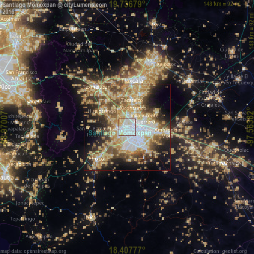
Analysis of Santiago Momoxpan night lights 2016
Square area 10x10 km:
 58.87%
90-99
25.54%80-89
10.61%70-79
4.98%60-69
0%50-59
0%40-49
0%30-39
0%20-29
0%10-19
0%0-9
0%Square area 50x50 km:
9.75%90-99
7.8%80-89
14.07%70-79
9.68%60-69
7.76%50-59
7.82%40-49
8.3%30-39
6.09%20-29
6.99%10-19
11.28%0-9
10.47%Clear (daylight) street map image can be seen on geolist.org.
Map coordinates:
19° 44' 12.4" North, 98° 58' 12.3" West
19° 4' 25" North, 98° 16' 1" West
18° 24' 28" North, 97° 33' 49.8" West
Some cities around Santiago Momoxpan sort by population:
• Cholula
4 km =2.5 mi,  254°
254°
• San Bernardino Tlaxcalancingo
5.1 km =3.2 mi,  191°
191°
• San Andrés Cholula
3.9 km =2.4 mi,  230°
230°
• Sanctorum
3.1 km =1.9 mi,  25°
25°
• Cuautlancingo
1.9 km =1.2 mi,  340°
340°
• Coronango
6.7 km =4.2 mi,  322°
322°
• San Francisco Ocotlán
6.9 km =4.3 mi,  345°
345°
• Cuanalá
7.5 km =4.7 mi,  301°
301°
3523061 (p: 17,622)
Sources (retrieved 2019-11-25):
» Earth at Night: Flat Maps 2012, 2016