San Francisco Ocotlán night lights from space
Night Light of San Francisco Ocotlán (Puebla) from space (Mexico) Src. Average luminocity for 10x10km area is 83.4048% and for 50x50km: 59.2898%.
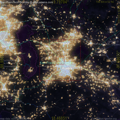
Analysis of San Francisco Ocotlán night lights 2016
Square area 10x10 km:
 14.94%
90-99
19.26%80-89
25.76%70-79
21.86%60-69
12.34%50-59
5.84%40-49
0%30-39
0%20-29
0%10-19
0%0-9
0%Square area 50x50 km:
10.32%90-99
8.51%80-89
15.83%70-79
10.55%60-69
8.48%50-59
8.62%40-49
9.09%30-39
5.91%20-29
6.94%10-19
8.23%0-9
7.51%Clear (daylight) street map image can be seen on geolist.org.
Map coordinates:
19° 47' 49.3" North, 98° 59' 11.7" West
19° 8' 2.8" North, 98° 17' 0.4" West
18° 28' 6.6" North, 97° 34' 49.2" West
Some cities around San Francisco Ocotlán sort by population:
• Sanctorum
5 km =3.1 mi,  141°
141°
• Cuautlancingo
5 km =3.1 mi,  167°
167°
• Coronango
2.8 km =1.7 mi,  238°
238°
• Almecatla
5.1 km =3.2 mi,  78°
78°
• Xicohtzinco
6.8 km =4.2 mi,  49°
49°
• San Miguel Xoxtla
4.5 km =2.8 mi,  325°
325°
• San Antonio Mihuacán
3.1 km =1.9 mi,  313°
313°
• Cuanalá
5.4 km =3.4 mi, 239°
3522454 (p: 11,636)
Sources (retrieved 2019-11-25):
» Earth at Night: Flat Maps 2012, 2016