Santa María Jalapa del Marqués night lights from space
Night Light of Santa María Jalapa del Marqués (Oaxaca) from space (Mexico) Src. Average luminocity for 10x10km area is 3.5186% and for 50x50km: 2.9539%.
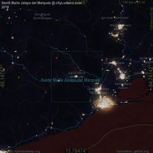
Analysis of Santa María Jalapa del Marqués night lights 2016
Square area 10x10 km:
 0%
0%90-99
0.83%80-89
0.83%70-79
0%60-69
0%50-59
1.65%40-49
0%30-39
1.65%20-29
0.83%10-19
0%0-9
94.21%Square area 50x50 km:
0.18%90-99
0.67%80-89
0.36%70-79
0.42%60-69
0.27%50-59
0.42%40-49
0.51%30-39
0.61%20-29
1.11%10-19
1.74%0-9
93.7%Clear (daylight) street map image can be seen on geolist.org.
Map coordinates:
17° 6' 48.5" North, 96° 8' 51.6" West
16° 26' 25" North, 95° 26' 40.3" West
15° 45' 53.1" North, 94° 44' 29.1" West
Some cities around Santa María Jalapa del Marqués sort by population:
• Salina Cruz
39.8 km =24.7 mi,  137°
137°
• Juchitán de Zaragoza
45.3 km =28.1 mi,  90°
90°
• Santo Domingo Tehuantepec
25.2 km =15.7 mi,  120°
120°
• Ixtepec
38.7 km =24 mi,  69°
69°
• San Blas Atempa
26.3 km =16.3 mi, 117°
• Jalapa
7 km =4.3 mi,  340°
340°
• El Espinal
43.4 km =27 mi,  83°
83°
• Asunción Ixtaltepec
41.5 km =25.8 mi, 80°
3801642 (p: 8,996)
Sources (retrieved 2019-11-25):
» Earth at Night: Flat Maps 2012, 2016