Jalapa night lights from space
Night Light of Jalapa (Oaxaca) from space (Mexico) Src. Average luminocity for 10x10km area is 0.3202% and for 50x50km: 1.2541%.
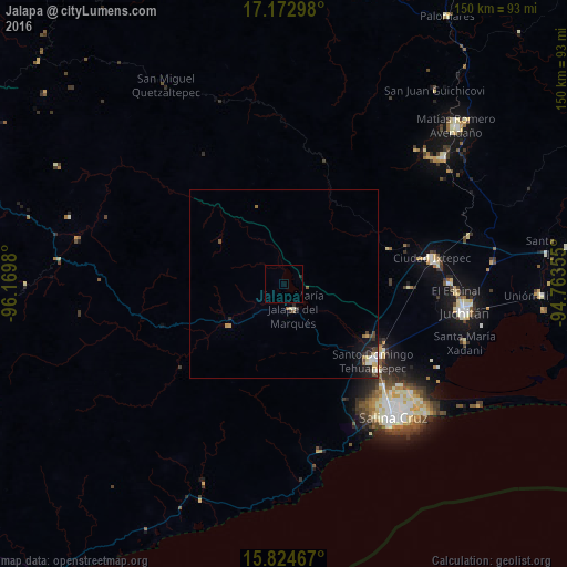
Analysis of Jalapa night lights 2016
Square area 10x10 km:
 0%
0%90-99
0%80-89
0%70-79
0%60-69
0%50-59
0%40-49
0%30-39
0%20-29
0.83%10-19
0%0-9
99.17%Square area 50x50 km:
0.09%90-99
0.24%80-89
0.21%70-79
0.16%60-69
0.07%50-59
0.19%40-49
0.2%30-39
0.19%20-29
0.38%10-19
1.04%0-9
97.24%Clear (daylight) street map image can be seen on geolist.org.
Map coordinates:
17° 10' 22.7" North, 96° 10' 11.3" West
16° 30' 0" North, 95° 28' 0" West
15° 49' 28.8" North, 94° 45' 48.8" West
Some cities around Jalapa sort by population:
• Salina Cruz
46.3 km =28.8 mi,  141°
141°
• Juchitán de Zaragoza
48.2 km =30 mi,  98°
98°
• Santo Domingo Tehuantepec
31 km =19.3 mi,  129°
129°
• Ixtepec
39.3 km =24.4 mi,  80°
80°
• San Blas Atempa
31.8 km =19.8 mi, 126°
• Santa María Jalapa del Marqués
7 km =4.3 mi,  160°
160°
• El Espinal
45.5 km =28.3 mi,  92°
92°
• Asunción Ixtaltepec
43.2 km =26.8 mi, 89°
3526621 (p: 8,289)
Sources (retrieved 2019-11-25):
» Earth at Night: Flat Maps 2012, 2016