La Estancia night lights from space
Night Light of La Estancia (Querétaro) from space (Mexico) Src. Average luminocity for 10x10km area is 45.1136% and for 50x50km: 23.5613%.
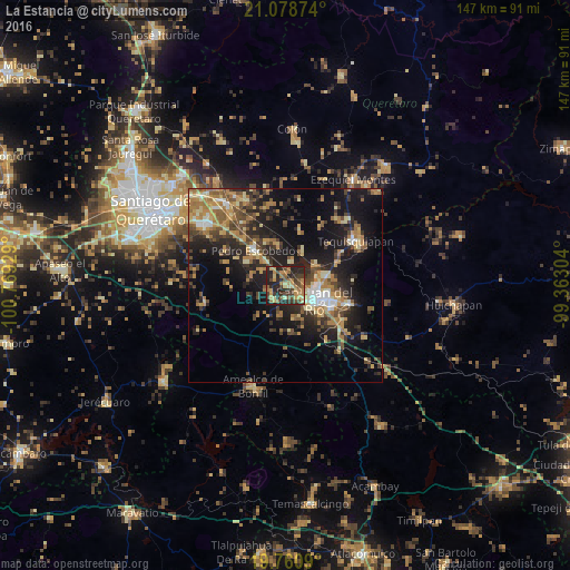
Analysis of La Estancia night lights 2016
Square area 10x10 km:
 0%
0%90-99
1.7%80-89
8.14%70-79
9.85%60-69
13.45%50-59
6.06%40-49
11.36%30-39
12.12%20-29
28.98%10-19
8.14%0-9
0.19%Square area 50x50 km:
1.32%90-99
1.88%80-89
3.68%70-79
3.94%60-69
5.31%50-59
3.17%40-49
5.01%30-39
4.4%20-29
8.01%10-19
15.96%0-9
47.32%Clear (daylight) street map image can be seen on geolist.org.
Map coordinates:
21° 4' 43.5" North, 100° 46' 9.4" West
20° 25' 16.4" North, 100° 3' 58.2" West
19° 45' 39.2" North, 99° 21' 46.9" West
Some cities around La Estancia sort by population:
• San Juan del Río
8.2 km =5.1 mi,  116°
116°
• Tequisquiapan
21.4 km =13.3 mi,  58°
58°
• Pedro Escobedo
11.8 km =7.3 mi,  317°
317°
• El Saúz
8.1 km =5 mi, 320°
• La Lira
11.6 km =7.2 mi,  301°
301°
• La Valla
9.6 km =6 mi,  25°
25°
• San Nicolás
14.8 km =9.2 mi,  65°
65°
• La Llave
9.1 km =5.7 mi, 56°
4002462 (p: 5,992)
Sources (retrieved 2019-11-25):
» Earth at Night: Flat Maps 2012, 2016