San Juan Zitlaltepec night lights from space
Night Light of San Juan Zitlaltepec (Morelos) from space (Mexico) Src. Average luminocity for 10x10km area is 65.405% and for 50x50km: 59.8918%.
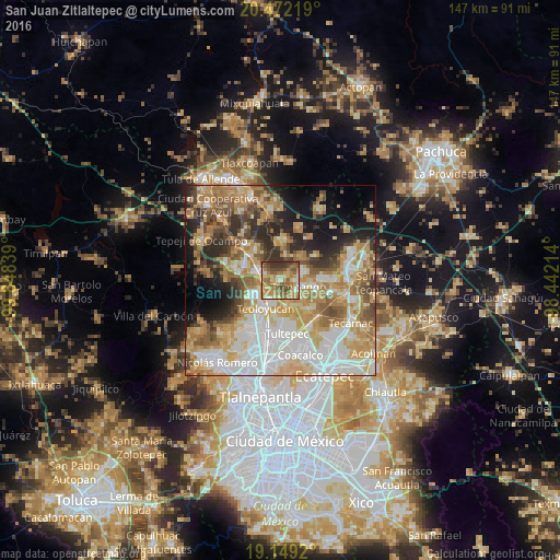
Analysis of San Juan Zitlaltepec night lights 2016
Square area 10x10 km:
 3.31%
3.31%90-99
6.2%80-89
12.81%70-79
19.63%60-69
23.35%50-59
15.08%40-49
9.5%30-39
9.92%20-29
0.21%10-19
0%0-9
0%Square area 50x50 km:
13.52%90-99
10.78%80-89
10%70-79
11.16%60-69
11.3%50-59
6.79%40-49
6.2%30-39
5.72%20-29
7.44%10-19
8.52%0-9
8.59%Clear (daylight) street map image can be seen on geolist.org.
Map coordinates:
20° 28' 19.9" North, 99° 50' 54.2" West
19° 48' 43.5" North, 99° 8' 42.9" West
19° 8' 57.1" North, 98° 26' 31.7" West
Some cities around San Juan Zitlaltepec sort by population:
• Zumpango
5.1 km =3.2 mi,  109°
109°
• Coyotepec
8.1 km =5 mi,  241°
241°
• Huehuetoca
6.4 km =4 mi,  286°
286°
• Fraccionamiento la Trinidad
6.8 km =4.2 mi,  73°
73°
• Ex-hacienda de Xalpa
4.1 km =2.5 mi,  284°
284°
• San Bartolo
5.5 km =3.4 mi,  295°
295°
• Salitrillo
7.6 km =4.7 mi, 284°
• Miguel Bocanegra
5.1 km =3.2 mi,  42°
42°
3518593 (p: 19,600)
Sources (retrieved 2019-11-25):
» Earth at Night: Flat Maps 2012, 2016