Ex-hacienda de Xalpa night lights from space
Night Light of Ex-hacienda de Xalpa (México) from space (Mexico) Src. Average luminocity for 10x10km area is 66.316% and for 50x50km: 55.33%.
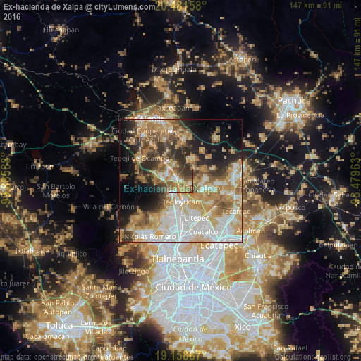
Analysis of Ex-hacienda de Xalpa night lights 2016
Square area 10x10 km:
 6.49%
6.49%90-99
10.17%80-89
13.2%70-79
13.2%60-69
21%50-59
13.85%40-49
6.93%30-39
13.42%20-29
1.73%10-19
0%0-9
0%Square area 50x50 km:
12.21%90-99
9.69%80-89
8.71%70-79
10.12%60-69
10.69%50-59
6.15%40-49
5.85%30-39
5.96%20-29
8%10-19
10.11%0-9
12.53%Clear (daylight) street map image can be seen on geolist.org.
Map coordinates:
20° 28' 53.7" North, 99° 53' 9.2" West
19° 49' 17.4" North, 99° 10' 57.9" West
19° 9' 31.2" North, 98° 28' 46.7" West
Some cities around Ex-hacienda de Xalpa sort by population:
• Santa Teresa
5.9 km =3.7 mi,  296°
296°
• Coyotepec
5.9 km =3.7 mi,  212°
212°
• San Juan Zitlaltepec
4.1 km =2.5 mi,  104°
104°
• Huehuetoca
2.3 km =1.4 mi,  288°
288°
• San Bartolo
1.6 km =1 mi,  320°
320°
• Santa Cruz del Monte
7.7 km =4.8 mi,  218°
218°
• Salitrillo
3.6 km =2.2 mi,  284°
284°
• Miguel Bocanegra
7.9 km =4.9 mi,  70°
70°
3526606 (p: 9,105)
Sources (retrieved 2019-11-25):
» Earth at Night: Flat Maps 2012, 2016