Salitrillo night lights from space
Night Light of Salitrillo (Hidalgo) from space (Mexico) Src. Average luminocity for 10x10km area is 70.171% and for 50x50km: 51.4393%.
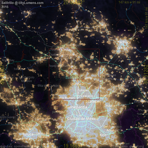
Analysis of Salitrillo night lights 2016
Square area 10x10 km:
 9.52%
9.52%90-99
12.34%80-89
14.94%70-79
10.82%60-69
17.97%50-59
17.97%40-49
9.74%30-39
5.41%20-29
1.3%10-19
0%0-9
0%Square area 50x50 km:
11.1%90-99
8.42%80-89
7.7%70-79
9.27%60-69
10.22%50-59
6.19%40-49
5.97%30-39
6.01%20-29
7.86%10-19
10.59%0-9
16.67%Clear (daylight) street map image can be seen on geolist.org.
Map coordinates:
20° 29' 21.9" North, 99° 55' 8.7" West
19° 49' 45.7" North, 99° 12' 57.4" West
19° 9' 59.7" North, 98° 30' 46.2" West
Some cities around Salitrillo sort by population:
• Teoloyucan
10.1 km =6.3 mi,  158°
158°
• Santa Teresa
2.5 km =1.6 mi,  313°
313°
• Coyotepec
5.8 km =3.6 mi,  176°
176°
• San Juan Zitlaltepec
7.6 km =4.7 mi,  104°
104°
• Huehuetoca
1.3 km =0.8 mi, 95°
• Ex-hacienda de Xalpa
3.6 km =2.2 mi, 104°
• San Bartolo
2.5 km =1.6 mi,  80°
80°
• Santa Cruz del Monte
7.1 km =4.4 mi,  190°
190°
3827552 (p: 6,231)
Sources (retrieved 2019-11-25):
» Earth at Night: Flat Maps 2012, 2016