San Lorenzo Chiautzingo night lights from space
Night Light of San Lorenzo Chiautzingo (Puebla) from space (Mexico) Src. Average luminocity for 10x10km area is 44.4524% and for 50x50km: 35.3377%.
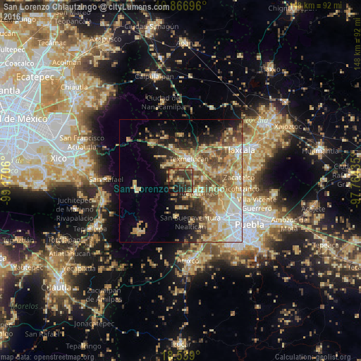
Analysis of San Lorenzo Chiautzingo night lights 2016
Square area 10x10 km:
 0%
0%90-99
0.43%80-89
10.82%70-79
4.11%60-69
12.55%50-59
8.66%40-49
12.55%30-39
22.94%20-29
17.1%10-19
10.39%0-9
0.43%Square area 50x50 km:
4.26%90-99
3.81%80-89
9.07%70-79
6.93%60-69
6.12%50-59
5.37%40-49
6%30-39
3.97%20-29
5.33%10-19
8.96%0-9
40.18%Clear (daylight) street map image can be seen on geolist.org.
Map coordinates:
19° 52' 1.1" North, 99° 10' 14.2" West
19° 12' 15.6" North, 98° 28' 2.9" West
18° 32' 20.4" North, 97° 45' 51.7" West
Some cities around San Lorenzo Chiautzingo sort by population:
• San Martin Texmelucan de Labastida
9.4 km =5.8 mi,  18°
18°
• Moyotzingo
8.2 km =5.1 mi,  53°
53°
• Huejotzingo
8 km =5 mi,  129°
129°
• Santa Ana Xalmimilulco
9 km =5.6 mi,  83°
83°
• San Rafael Tlanalapan
9.7 km =6 mi,  359°
359°
• San Juan Tuxco
6.3 km =3.9 mi, 15°
• Teotlaltzingo
4.6 km =2.9 mi,  310°
310°
• Domingo Arenas
7.2 km =4.5 mi,  171°
171°
3518542 (p: 7,477)
Sources (retrieved 2019-11-25):
» Earth at Night: Flat Maps 2012, 2016