Teotlaltzingo night lights from space
Night Light of Teotlaltzingo (Puebla) from space (Mexico) Src. Average luminocity for 10x10km area is 48.2857% and for 50x50km: 28.6052%.
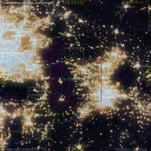
Analysis of Teotlaltzingo night lights 2016
Square area 10x10 km:
 0%
0%90-99
1.52%80-89
17.97%70-79
8.87%60-69
11.26%50-59
6.06%40-49
10.17%30-39
13.85%20-29
12.12%10-19
13.85%0-9
4.33%Square area 50x50 km:
1.67%90-99
2.51%80-89
7.67%70-79
5.55%60-69
5.56%50-59
5.01%40-49
5.71%30-39
3.77%20-29
4.88%10-19
9.25%0-9
48.41%Clear (daylight) street map image can be seen on geolist.org.
Map coordinates:
19° 53' 36.3" North, 99° 12' 14" West
19° 13' 51.2" North, 98° 30' 2.8" West
18° 33' 56.4" North, 97° 47' 51.5" West
Some cities around Teotlaltzingo sort by population:
• San Martin Texmelucan de Labastida
8.8 km =5.5 mi,  47°
47°
• Moyotzingo
10.2 km =6.3 mi,  79°
79°
• San Rafael Tlanalapan
7.6 km =4.7 mi,  26°
26°
• San Matias Tlalancaleca
10.5 km =6.5 mi,  1°
1°
• San Lucas el Grande
8.7 km =5.4 mi,  15°
15°
• San Lorenzo Chiautzingo
4.6 km =2.9 mi,  130°
130°
• San Juan Tuxco
6.1 km =3.8 mi,  58°
58°
• Domingo Arenas
11.1 km =6.9 mi,  155°
155°
3519405 (p: 6,166)
Sources (retrieved 2019-11-25):
» Earth at Night: Flat Maps 2012, 2016