San Juan Cosalá night lights from space
Night Light of San Juan Cosalá (Jalisco) from space (Mexico) Src. Average luminocity for 10x10km area is 11.3036% and for 50x50km: 17.7107%.
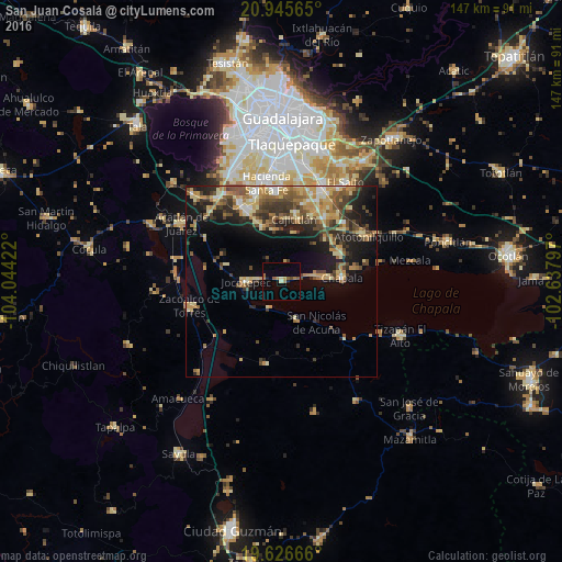
Analysis of San Juan Cosalá night lights 2016
Square area 10x10 km:
 0%
0%90-99
0.79%80-89
0.79%70-79
1.19%60-69
3.97%50-59
2.38%40-49
1.59%30-39
0%20-29
0.79%10-19
2.18%0-9
86.31%Square area 50x50 km:
1.06%90-99
1.64%80-89
3.69%70-79
3.54%60-69
2.78%50-59
2.62%40-49
3.61%30-39
3.04%20-29
4.14%10-19
9.13%0-9
64.77%Clear (daylight) street map image can be seen on geolist.org.
Map coordinates:
20° 56' 44.3" North, 104° 2' 39.2" West
20° 17' 15.2" North, 103° 20' 27.9" West
19° 37' 36" North, 102° 38' 16.7" West
Some cities around San Juan Cosalá sort by population:
• Chapala
15.7 km =9.8 mi,  86°
86°
• Jocotepec
9.2 km =5.7 mi,  268°
268°
• Ajijic
9.2 km =5.7 mi,  79°
79°
• Los Olivos
20 km =12.4 mi,  32°
32°
• San Miguel Cuyutlán
15.2 km =9.4 mi,  340°
340°
• Ixtlahuacán de los Membrillos
16.8 km =10.4 mi,  66°
66°
• Galaxia la Noria
20.5 km =12.7 mi, 336°
• Cajititlán
16.4 km =10.2 mi,  11°
11°
3985913 (p: 6,973)
Sources (retrieved 2019-11-25):
» Earth at Night: Flat Maps 2012, 2016