Los Olivos night lights from space
Night Light of Los Olivos (Jalisco) from space (Mexico) Src. Average luminocity for 10x10km area is 59.4527% and for 50x50km: 38.7734%.
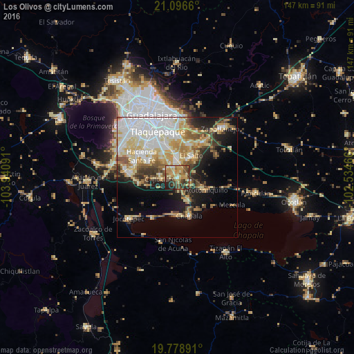
Analysis of Los Olivos night lights 2016
Square area 10x10 km:
 3.6%
3.6%90-99
5.49%80-89
15.72%70-79
17.61%60-69
8.71%50-59
9.28%40-49
15.34%30-39
10.04%20-29
10.23%10-19
3.98%0-9
0%Square area 50x50 km:
9.64%90-99
6.78%80-89
7.76%70-79
5.82%60-69
4.09%50-59
3.6%40-49
4.5%30-39
3.72%20-29
5.12%10-19
10.06%0-9
38.9%Clear (daylight) street map image can be seen on geolist.org.
Map coordinates:
21° 5' 47.8" North, 103° 56' 27.3" West
20° 26' 21" North, 103° 14' 16" West
19° 46' 44.1" North, 102° 32' 4.8" West
Some cities around Los Olivos sort by population:
• El Salto
10.6 km =6.6 mi,  33°
33°
• San José del Castillo
8.3 km =5.2 mi,  359°
359°
• Juanacatlán
10.5 km =6.5 mi,  42°
42°
• Galaxia Bonito Jalisco
8.1 km =5 mi, 25°
• La Alameda
6.3 km =3.9 mi,  350°
350°
• Capulín
5.4 km =3.4 mi,  322°
322°
• Rancho Alegre [Fraccionamiento]
4.4 km =2.7 mi,  331°
331°
• Cajititlán
7.5 km =4.7 mi,  263°
263°
8858191 (p: 7,647)
Sources (retrieved 2019-11-25):
» Earth at Night: Flat Maps 2012, 2016