Cajititlán night lights from space
Night Light of Cajititlán (Jalisco) from space (Mexico) Src. Average luminocity for 10x10km area is 41.0265% and for 50x50km: 39.2411%.
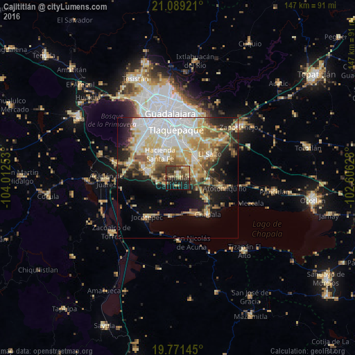
Analysis of Cajititlán night lights 2016
Square area 10x10 km:
 1.14%
1.14%90-99
2.65%80-89
8.14%70-79
7.2%60-69
6.25%50-59
6.25%40-49
11.36%30-39
16.48%20-29
14.58%10-19
22.35%0-9
3.6%Square area 50x50 km:
8.95%90-99
6.94%80-89
7.97%70-79
6.12%60-69
4.03%50-59
3.71%40-49
4.81%30-39
4.13%20-29
6.21%10-19
10.45%0-9
36.69%Clear (daylight) street map image can be seen on geolist.org.
Map coordinates:
21° 5' 21.2" North, 104° 0' 45.1" West
20° 25' 54.3" North, 103° 18' 33.8" West
19° 46' 17.2" North, 102° 36' 22.6" West
Some cities around Cajititlán sort by population:
• San José del Castillo
11.8 km =7.3 mi,  39°
39°
• Valle Dorado Inn
11.7 km =7.3 mi,  332°
332°
• La Alameda
9.5 km =5.9 mi, 42°
• Capulín
6.6 km =4.1 mi, 38°
• Rancho Alegre [Fraccionamiento]
7.1 km =4.4 mi,  49°
49°
• Los Olivos
7.5 km =4.7 mi,  83°
83°
• San Miguel Cuyutlán
8.6 km =5.3 mi,  258°
258°
• Galaxia la Noria
11.8 km =7.3 mi,  283°
283°
4016272 (p: 5,323)
Sources (retrieved 2019-11-25):
» Earth at Night: Flat Maps 2012, 2016