San Gaspar Tonatico night lights from space
Night Light of San Gaspar Tonatico (México) from space (Mexico) Src. Average luminocity for 10x10km area is 21.119% and for 50x50km: 16.7382%.
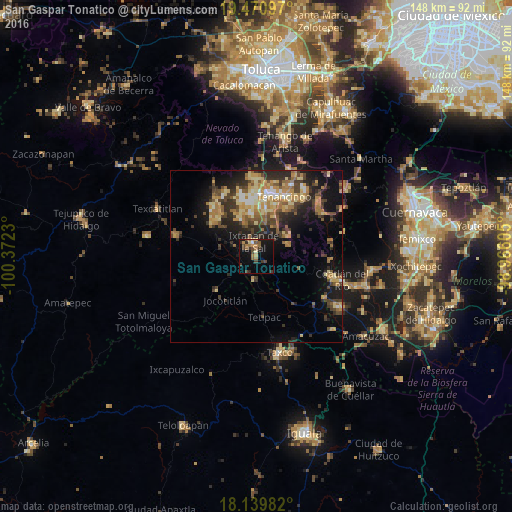
Analysis of San Gaspar Tonatico night lights 2016
Square area 10x10 km:
 0.22%
0.22%90-99
0.65%80-89
2.16%70-79
3.9%60-69
5.41%50-59
3.46%40-49
5.41%30-39
6.06%20-29
2.16%10-19
19.91%0-9
50.65%Square area 50x50 km:
0.87%90-99
1.34%80-89
3.43%70-79
2.83%60-69
3.52%50-59
1.88%40-49
3.61%30-39
3.46%20-29
4.91%10-19
9.16%0-9
65%Clear (daylight) street map image can be seen on geolist.org.
Map coordinates:
19° 28' 15.5" North, 100° 22' 20.3" West
18° 48' 24.2" North, 99° 40' 9" West
18° 8' 23.4" North, 98° 57' 57.8" West
Some cities around San Gaspar Tonatico sort by population:
• Ixtapan de la Sal
4.2 km =2.6 mi,  349°
349°
• Tenancingo de Degollado
19.1 km =11.9 mi,  25°
25°
• La Joya
26.4 km =16.4 mi,  126°
126°
• Villa Guerrero
17.5 km =10.9 mi,  9°
9°
• Malinalco
24.1 km =15 mi,  49°
49°
• Coatepec Harinas
11.2 km =7 mi,  330°
330°
• Santa Ana Ixtlahuatzingo (Santa Ana)
18.8 km =11.7 mi, 14°
• Pilcaya
6.7 km =4.2 mi,  185°
185°
3519227 (p: 7,565)
Sources (retrieved 2019-11-25):
» Earth at Night: Flat Maps 2012, 2016