Ixtapan de la Sal night lights from space
Night Light of Ixtapan de la Sal (México) from space (Mexico) Src. Average luminocity for 10x10km area is 28.7965% and for 50x50km: 16.9265%.
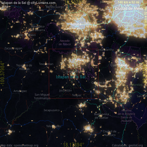
Analysis of Ixtapan de la Sal night lights 2016
Square area 10x10 km:
 0.22%
0.22%90-99
0.65%80-89
2.6%70-79
4.33%60-69
6.28%50-59
3.9%40-49
7.58%30-39
6.71%20-29
22.29%10-19
30.74%0-9
14.72%Square area 50x50 km:
0.87%90-99
1.3%80-89
3.43%70-79
2.74%60-69
3.56%50-59
1.94%40-49
3.58%30-39
3.39%20-29
5.01%10-19
10.88%0-9
63.3%Clear (daylight) street map image can be seen on geolist.org.
Map coordinates:
19° 30' 28.1" North, 100° 22' 47.4" West
18° 50' 37.3" North, 99° 40' 36.2" West
18° 10' 37" North, 98° 58' 24.9" West
Some cities around Ixtapan de la Sal sort by population:
• Tenancingo de Degollado
15.9 km =9.9 mi,  34°
34°
• Villa Guerrero
13.7 km =8.5 mi,  16°
16°
• Malinalco
22.3 km =13.9 mi,  58°
58°
• San Gaspar Tonatico
4.2 km =2.6 mi,  169°
169°
• Coatepec Harinas
7.4 km =4.6 mi,  320°
320°
• Santa Ana Ixtlahuatzingo (Santa Ana)
15.2 km =9.4 mi, 21°
• San Pedro Zictepec
23.8 km =14.8 mi, 25°
• Pilcaya
10.8 km =6.7 mi,  179°
179°
3526681 (p: 17,640)
Sources (retrieved 2019-11-25):
» Earth at Night: Flat Maps 2012, 2016