Coatepec Harinas night lights from space
Night Light of Coatepec Harinas (México) from space (Mexico) Src. Average luminocity for 10x10km area is 40.9091% and for 50x50km: 16.4189%.
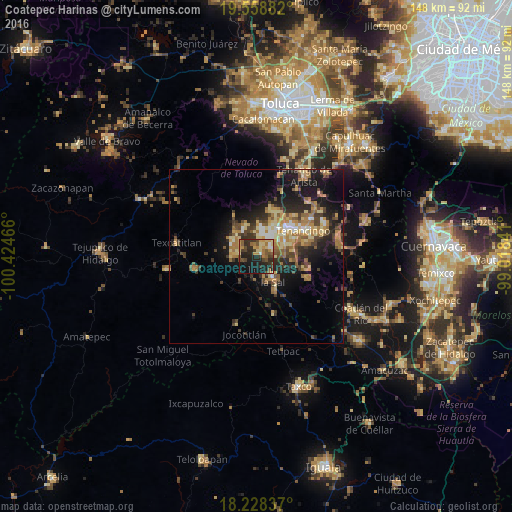
Analysis of Coatepec Harinas night lights 2016
Square area 10x10 km:
 1.52%
1.52%90-99
2.16%80-89
8.66%70-79
8.01%60-69
7.36%50-59
6.06%40-49
10.39%30-39
7.79%20-29
22.29%10-19
21.86%0-9
3.9%Square area 50x50 km:
0.84%90-99
1.33%80-89
3.25%70-79
2.82%60-69
3.42%50-59
2.02%40-49
3.27%30-39
3.02%20-29
5.07%10-19
10.55%0-9
64.4%Clear (daylight) street map image can be seen on geolist.org.
Map coordinates:
19° 33' 31.8" North, 100° 25' 28.8" West
18° 53' 41.7" North, 99° 43' 17.5" West
18° 13' 42.1" North, 99° 1' 6.3" West
Some cities around Coatepec Harinas sort by population:
• Ixtapan de la Sal
7.4 km =4.6 mi,  140°
140°
• Tenancingo de Degollado
15.7 km =9.8 mi,  61°
61°
• Villa Guerrero
11.3 km =7 mi,  48°
48°
• San Gaspar Tonatico
11.2 km =7 mi,  150°
150°
• Santa Ana Ixtlahuatzingo (Santa Ana)
13.3 km =8.3 mi, 50°
• San Pedro Zictepec
21.8 km =13.5 mi,  43°
43°
• San Pedro Tlanixco
20 km =12.4 mi,  21°
21°
• Pilcaya
17.2 km =10.7 mi,  163°
163°
3530527 (p: 7,243)
Sources (retrieved 2019-11-25):
» Earth at Night: Flat Maps 2012, 2016