Malinalco night lights from space
Night Light of Malinalco (México) from space (Mexico) Src. Average luminocity for 10x10km area is 34.3506% and for 50x50km: 23.1645%.
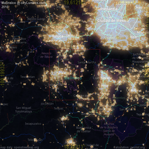
Analysis of Malinalco night lights 2016
Square area 10x10 km:
 1.3%
1.3%90-99
1.08%80-89
3.25%70-79
8.01%60-69
8.23%50-59
2.16%40-49
10.17%30-39
8.44%20-29
18.18%10-19
37.66%0-9
1.52%Square area 50x50 km:
0.87%90-99
1.44%80-89
4.87%70-79
3.68%60-69
4.97%50-59
2.96%40-49
4.48%30-39
4.14%20-29
8.32%10-19
17.1%0-9
47.17%Clear (daylight) street map image can be seen on geolist.org.
Map coordinates:
19° 36' 43.8" North, 100° 11' 57.6" West
18° 56' 54.5" North, 99° 29' 46.3" West
18° 16' 55.7" North, 98° 47' 35.1" West
Some cities around Malinalco sort by population:
• Tenango de Arista
19.9 km =12.4 mi,  330°
330°
• Tenancingo de Degollado
10 km =6.2 mi,  278°
278°
• Villa Guerrero
15.3 km =9.5 mi, 275°
• Santa María Jajalpa
18.6 km =11.6 mi,  347°
347°
• Santa Ana Ixtlahuatzingo (Santa Ana)
13.6 km =8.5 mi, 280°
• San Bartolomé Atlatlahuca
18 km =11.2 mi,  318°
318°
• San Pedro Zictepec
13 km =8.1 mi, 318°
• San Pedro Tlanixco
20.8 km =12.9 mi,  307°
307°
3523686 (p: 8,045)
Sources (retrieved 2019-11-25):
» Earth at Night: Flat Maps 2012, 2016