Pilcaya night lights from space
Night Light of Pilcaya (Guerrero) from space (Mexico) Src. Average luminocity for 10x10km area is 4.8244% and for 50x50km: 13.2543%.
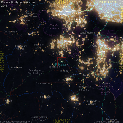
Analysis of Pilcaya night lights 2016
Square area 10x10 km:
 0%
0%90-99
0%80-89
0.83%70-79
0.41%60-69
0.41%50-59
0%40-49
1.03%30-39
3.1%20-29
1.24%10-19
1.03%0-9
91.94%Square area 50x50 km:
0.68%90-99
1.05%80-89
2.6%70-79
1.93%60-69
3.01%50-59
1.59%40-49
2.87%30-39
2.75%20-29
3.57%10-19
7.39%0-9
72.56%Clear (daylight) street map image can be seen on geolist.org.
Map coordinates:
19° 24' 41.1" North, 100° 22' 41.3" West
18° 44' 48.9" North, 99° 40' 30" West
18° 4' 47.2" North, 98° 58' 18.8" West
Some cities around Pilcaya sort by population:
• Taxco de Alarcón
22.6 km =14 mi,  161°
161°
• Ixtapan de la Sal
10.8 km =6.7 mi,  359°
359°
• La Joya
23.7 km =14.7 mi,  112°
112°
• Villa Guerrero
24.2 km =15 mi,  8°
8°
• San Gaspar Tonatico
6.7 km =4.2 mi, 5°
• Coatepec Harinas
17.2 km =10.7 mi,  343°
343°
• Santa Ana Ixtlahuatzingo (Santa Ana)
25.4 km =15.8 mi, 12°
• Acamixtla
23.2 km =14.4 mi,  150°
150°
3817354 (p: 5,270)
Sources (retrieved 2019-11-25):
» Earth at Night: Flat Maps 2012, 2016