Santa Ana Ixtlahuatzingo (Santa Ana) night lights from space
Night Light of Santa Ana Ixtlahuatzingo (Santa Ana) (México) from space (Mexico) Src. Average luminocity for 10x10km area is 75.9199% and for 50x50km: 23.1787%.
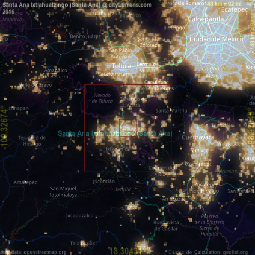
Analysis of Santa Ana Ixtlahuatzingo (Santa Ana) night lights 2016
Square area 10x10 km:
 8.44%
8.44%90-99
16.02%80-89
23.16%70-79
21.21%60-69
14.29%50-59
8.23%40-49
0.87%30-39
5.84%20-29
1.95%10-19
0%0-9
0%Square area 50x50 km:
1.04%90-99
1.66%80-89
4.92%70-79
3.92%60-69
5.2%50-59
2.71%40-49
4.42%30-39
4.32%20-29
7.35%10-19
15.26%0-9
49.21%Clear (daylight) street map image can be seen on geolist.org.
Map coordinates:
19° 38' 3" North, 100° 19' 36.3" West
18° 58' 14" North, 99° 37' 25" West
18° 18' 15.5" North, 98° 55' 13.8" West
Some cities around Santa Ana Ixtlahuatzingo (Santa Ana) sort by population:
• Ixtapan de la Sal
15.2 km =9.4 mi,  201°
201°
• Tenancingo de Degollado
3.6 km =2.2 mi,  106°
106°
• Villa Guerrero
2 km =1.2 mi,  242°
242°
• Malinalco
13.6 km =8.5 mi,  100°
100°
• Coatepec Harinas
13.3 km =8.3 mi,  230°
230°
• San Bartolomé Atlatlahuca
11.1 km =6.9 mi,  7°
7°
• San Pedro Zictepec
8.8 km =5.5 mi,  33°
33°
• San Pedro Tlanixco
10.7 km =6.6 mi,  343°
343°
3517763 (p: 6,697)
Sources (retrieved 2019-11-25):
» Earth at Night: Flat Maps 2012, 2016