Atotonilquillo night lights from space
Night Light of Atotonilquillo (Jalisco) from space (Mexico) Src. Average luminocity for 10x10km area is 20.7424% and for 50x50km: 23.6712%.
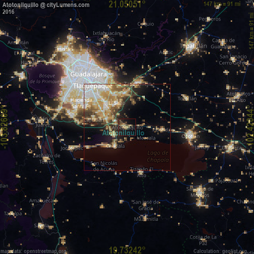
Analysis of Atotonilquillo night lights 2016
Square area 10x10 km:
 0%
0%90-99
1.14%80-89
3.03%70-79
3.41%60-69
1.52%50-59
1.89%40-49
7.39%30-39
2.08%20-29
9.09%10-19
29.36%0-9
41.1%Square area 50x50 km:
3.24%90-99
3.4%80-89
4.79%70-79
4.69%60-69
3.42%50-59
2.69%40-49
4%30-39
2.97%20-29
3.65%10-19
7.48%0-9
59.67%Clear (daylight) street map image can be seen on geolist.org.
Map coordinates:
21° 3' 1.8" North, 103° 49' 36.1" West
20° 23' 34.3" North, 103° 7' 24.8" West
19° 43' 56.7" North, 102° 25' 13.6" West
Some cities around Atotonilquillo sort by population:
• El Salto
15.3 km =9.5 mi,  336°
336°
• Chapala
12.9 km =8 mi,  213°
213°
• Juanacatlán
13.8 km =8.6 mi, 339°
• Galaxia Bonito Jalisco
15.1 km =9.4 mi,  325°
325°
• Los Olivos
13 km =8.1 mi,  293°
293°
• Atequiza
1.8 km =1.1 mi,  260°
260°
• Ixtlahuacán de los Membrillos
8.8 km =5.5 mi,  235°
235°
• Mezcala
12.8 km =8 mi,  119°
119°
4017990 (p: 7,249)
Sources (retrieved 2019-11-25):
» Earth at Night: Flat Maps 2012, 2016