Santa Clara del Cobre night lights from space
Night Light of Santa Clara del Cobre (Michoacán) from space (Mexico) Src. Average luminocity for 10x10km area is 9.1715% and for 50x50km: 3.8722%.
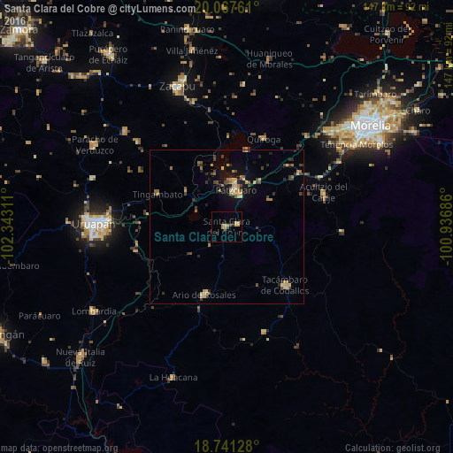
Analysis of Santa Clara del Cobre night lights 2016
Square area 10x10 km:
 0%
0%90-99
0%80-89
3.51%70-79
1.65%60-69
2.27%50-59
0%40-49
1.24%30-39
1.65%20-29
2.07%10-19
0%0-9
87.6%Square area 50x50 km:
0%90-99
0.15%80-89
0.86%70-79
0.64%60-69
0.77%50-59
0.32%40-49
0.97%30-39
0.62%20-29
0.87%10-19
1.82%0-9
92.98%Clear (daylight) street map image can be seen on geolist.org.
Map coordinates:
20° 4' 3.4" North, 102° 20' 35.2" West
19° 24' 20.9" North, 101° 38' 23.9" West
18° 44' 28.6" North, 100° 56' 12.7" West
Some cities around Santa Clara del Cobre sort by population:
• Pátzcuaro
12.7 km =7.9 mi,  14°
14°
• Tacámbaro de Codallos
26.9 km =16.7 mi,  134°
134°
• Ario de Rosales
23 km =14.3 mi,  197°
197°
• Quiroga
31.4 km =19.5 mi,  23°
23°
• Opopeo
3.7 km =2.3 mi,  79°
79°
• Tingambato
24.7 km =15.3 mi,  295°
295°
• Acuítzio del Canje
33.7 km =20.9 mi,  72°
72°
• Taretán
30.3 km =18.8 mi,  254°
254°
3980184 (p: 14,359)
Sources (retrieved 2019-11-25):
» Earth at Night: Flat Maps 2012, 2016