Tingambato night lights from space
Night Light of Tingambato (Michoacán) from space (Mexico) Src. Average luminocity for 10x10km area is 2.3533% and for 50x50km: 6.7038%.
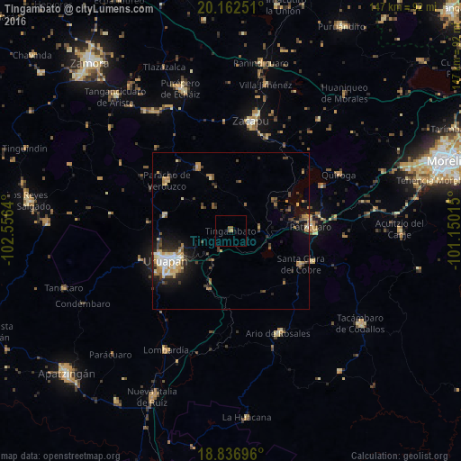
Analysis of Tingambato night lights 2016
Square area 10x10 km:
 0%
0%90-99
0%80-89
0%70-79
0%60-69
1.45%50-59
1.86%40-49
0%30-39
0%20-29
0%10-19
0%0-9
96.69%Square area 50x50 km:
0.62%90-99
0.8%80-89
1.11%70-79
1%60-69
1.03%50-59
0.59%40-49
1.37%30-39
0.94%20-29
1.71%10-19
3.53%0-9
87.3%Clear (daylight) street map image can be seen on geolist.org.
Map coordinates:
20° 9' 45" North, 102° 33' 23" West
19° 30' 3.9" North, 101° 51' 11.8" West
18° 50' 13.1" North, 101° 9' 0.5" West
Some cities around Tingambato sort by population:
• Uruapan
23.5 km =14.6 mi,  244°
244°
• Pátzcuaro
25.7 km =16 mi,  86°
86°
• Santa Clara del Cobre
24.7 km =15.3 mi,  115°
115°
• Cherán
23 km =14.3 mi,  332°
332°
• Nahuatzén
18.4 km =11.4 mi,  338°
338°
• Capácuaro
21.4 km =13.3 mi,  283°
283°
• Taretán
19.8 km =12.3 mi,  200°
200°
• Caltzontzín
18.3 km =11.4 mi, 241°
3981517 (p: 7,771)
Sources (retrieved 2019-11-25):
» Earth at Night: Flat Maps 2012, 2016