Adolfo Ruiz Cortines night lights from space
Night Light of Adolfo Ruiz Cortines (Sinaloa) from space (Mexico) Src. Average luminocity for 10x10km area is 9.3542% and for 50x50km: 5.2702%.
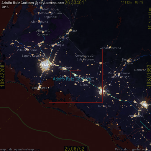
Analysis of Adolfo Ruiz Cortines night lights 2016
Square area 10x10 km:
 0.19%
0.19%90-99
0.95%80-89
2.08%70-79
1.33%60-69
0%50-59
1.89%40-49
1.7%30-39
2.46%20-29
0.76%10-19
0.19%0-9
88.45%Square area 50x50 km:
0.19%90-99
0.39%80-89
1.07%70-79
0.99%60-69
0.4%50-59
0.6%40-49
1.21%30-39
0.75%20-29
1.37%10-19
2.88%0-9
90.14%Clear (daylight) street map image can be seen on geolist.org.
Map coordinates:
26° 20' 4.6" North, 109° 25' 22.4" West
25° 42' 9.9" North, 108° 43' 11.1" West
25° 4' 3.1" North, 108° 0' 59.9" West
Some cities around Adolfo Ruiz Cortines sort by population:
• Los Mochis
29.6 km =18.4 mi,  289°
289°
• Guasave
29.4 km =18.3 mi,  120°
120°
• Leyva Solano
9.5 km =5.9 mi, 118°
• Juan José Ríos
12.1 km =7.5 mi,  300°
300°
• Constancia
34 km =21.1 mi,  328°
328°
• Topolobampo
35.2 km =21.9 mi,  251°
251°
• Naranjo
26.5 km =16.5 mi,  64°
64°
• Mochicahui
34.7 km =21.6 mi,  322°
322°
3976785 (p: 12,978)
Sources (retrieved 2019-11-25):
» Earth at Night: Flat Maps 2012, 2016