Montecillo night lights from space
Night Light of Montecillo (México) from space (Mexico) Src. Average luminocity for 10x10km area is 87.3988% and for 50x50km: 68.4003%.
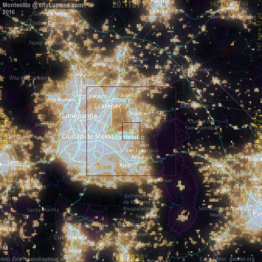
Analysis of Montecillo night lights 2016
Square area 10x10 km:
 29.13%
90-99
22.31%80-89
13.84%70-79
24.38%60-69
9.09%50-59
1.24%40-49
0%30-39
0%20-29
0%10-19
0%0-9
0%Square area 50x50 km:
29.37%90-99
12.94%80-89
12.04%70-79
9.7%60-69
5.56%50-59
3.01%40-49
3.01%30-39
2.2%20-29
2.94%10-19
4.51%0-9
14.72%Clear (daylight) street map image can be seen on geolist.org.
Map coordinates:
20° 7' 7.4" North, 99° 36' 41.3" West
19° 27' 25.6" North, 98° 54' 30.1" West
18° 47' 34.1" North, 98° 12' 18.8" West
Some cities around Montecillo sort by population:
• Santa María Chimalhuacán
5.9 km =3.7 mi,  228°
228°
• Chicoloapan
4.5 km =2.8 mi,  171°
171°
• Texcoco de Mora
6.7 km =4.2 mi,  23°
23°
• San Miguel Coatlinchán
3.8 km =2.4 mi,  101°
101°
• Tulantongo
9 km =5.6 mi, 23°
• Lomas de San Sebastián
8.7 km =5.4 mi,  197°
197°
• Santiago Cuautlalpan
2.9 km =1.8 mi, 165°
• San Bernardino
2.5 km =1.6 mi,  30°
30°
3523034 (p: 7,371)
Sources (retrieved 2019-11-25):
» Earth at Night: Flat Maps 2012, 2016