San Bernardino night lights from space
Night Light of San Bernardino (México) from space (Mexico) Src. Average luminocity for 10x10km area is 84.5413% and for 50x50km: 66.4198%.
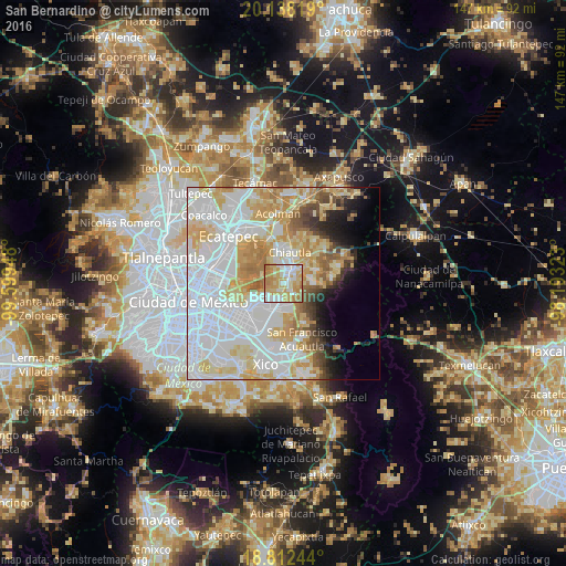
Analysis of San Bernardino night lights 2016
Square area 10x10 km:
 20.87%
90-99
18.8%80-89
19.01%70-79
28.1%60-69
12.6%50-59
0.62%40-49
0%30-39
0%20-29
0%10-19
0%0-9
0%Square area 50x50 km:
27.25%90-99
12.8%80-89
12.09%70-79
9.52%60-69
5.96%50-59
3.32%40-49
2.95%30-39
2.14%20-29
2.87%10-19
4.43%0-9
16.67%Clear (daylight) street map image can be seen on geolist.org.
Map coordinates:
20° 8' 17.5" North, 99° 35' 58.1" West
19° 28' 36" North, 98° 53' 46.9" West
18° 48' 44.8" North, 98° 11' 35.6" West
Some cities around San Bernardino sort by population:
• Chicoloapan
6.7 km =4.2 mi,  185°
185°
• Texcoco de Mora
4.2 km =2.6 mi,  19°
19°
• San Miguel Coatlinchán
3.9 km =2.4 mi,  140°
140°
• Tulantongo
6.5 km =4 mi, 20°
• Santiago Cuautlalpan
5 km =3.1 mi, 186°
• Montecillo
2.5 km =1.6 mi,  210°
210°
• Tequexquináhuac
7.5 km =4.7 mi,  89°
89°
• Xocotlán
6.9 km =4.3 mi,  49°
49°
3519620 (p: 5,667)
Sources (retrieved 2019-11-25):
» Earth at Night: Flat Maps 2012, 2016