Miahuatlán night lights from space
Night Light of Miahuatlán (Puebla) from space (Mexico) Src. Average luminocity for 10x10km area is 26.7004% and for 50x50km: 10.9513%.
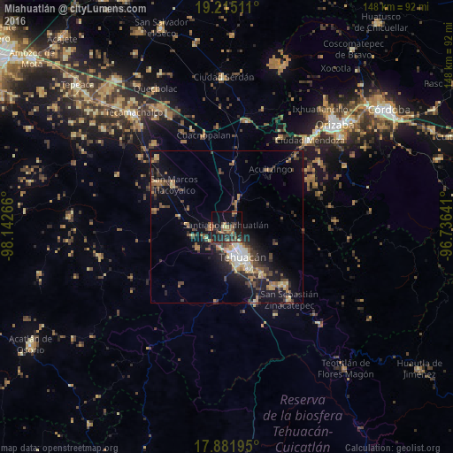
Analysis of Miahuatlán night lights 2016
Square area 10x10 km:
 0%
0%90-99
0%80-89
3.31%70-79
3.72%60-69
6.4%50-59
4.96%40-49
8.88%30-39
5.79%20-29
13.22%10-19
27.69%0-9
26.03%Square area 50x50 km:
0.75%90-99
0.84%80-89
1.43%70-79
1.42%60-69
1.88%50-59
1.57%40-49
2.56%30-39
2.44%20-29
3.18%10-19
8.71%0-9
75.22%Clear (daylight) street map image can be seen on geolist.org.
Map coordinates:
19° 12' 54.4" North, 98° 8' 33.6" West
18° 32' 59.4" North, 97° 26' 22.3" West
17° 52' 55" North, 96° 44' 11.1" West
Some cities around Miahuatlán sort by population:
• Tehuacán
10.5 km =6.5 mi,  154°
154°
• Altepexi
24.8 km =15.4 mi,  143°
143°
• San Marcos Tlacoyalco
22.1 km =13.7 mi,  308°
308°
• Magdalena Cuayucatepec
4.8 km =3 mi,  269°
269°
• Acultzingo
23.6 km =14.7 mi,  37°
37°
• Santa María la Alta
23.7 km =14.7 mi,  283°
283°
• Teontepec
11.5 km =7.1 mi,  235°
235°
• Chapulco
9.2 km =5.7 mi,  23°
23°
3516936 (p: 13,909)
Sources (retrieved 2019-11-25):
» Earth at Night: Flat Maps 2012, 2016