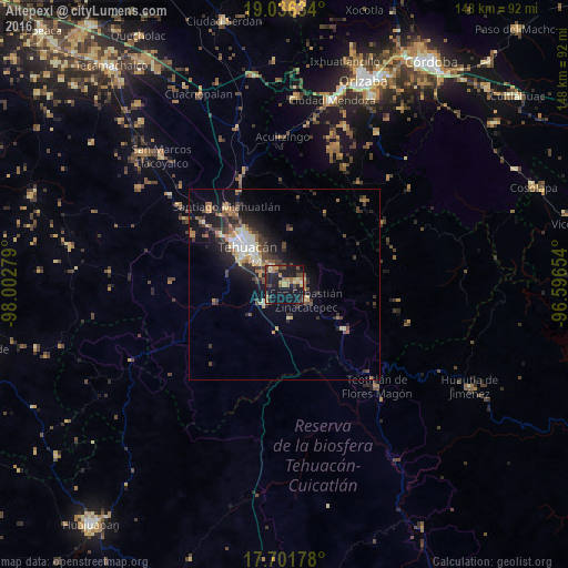
Altepexi night lights from space
Night Light of Altepexi (Puebla) from space (Mexico) Src. Average luminocity for 10x10km area is 31.4628% and for 50x50km: 9.1637%.
Analysis of Altepexi night lights 2016
Square area 10x10 km:
 0.41%
0.41%90-99
0.62%80-89
4.55%70-79
9.09%60-69
4.75%50-59
4.34%40-49
5.17%30-39
7.44%20-29
10.54%10-19
45.45%0-9
7.64%Square area 50x50 km:
0.75%90-99
0.87%80-89
1.34%70-79
1.19%60-69
1.36%50-59
1.1%40-49
1.96%30-39
2.08%20-29
2.91%10-19
7.3%0-9
79.15%Clear (daylight) street map image can be seen on geolist.org.
Map coordinates:
19° 2' 10.8" North, 98° 0' 10" West
18° 22' 13.3" North, 97° 17' 58.8" West
17° 42' 6.4" North, 96° 35' 47.5" West
Some cities around Altepexi sort by population:
• Tehuacán
14.7 km =9.1 mi,  315°
315°
• Ajalpan
4.4 km =2.7 mi,  77°
77°
• Zinacatepec
6.9 km =4.3 mi,  124°
124°
• Miahuatlán
24.8 km =15.4 mi, 323°
• San Gabriel Chilac
7 km =4.3 mi,  225°
225°
• Miahuatlán
8.8 km =5.5 mi,  171°
171°
• Coxcatlán
19.5 km =12.1 mi,  126°
126°
• Teontepec
27.8 km =17.3 mi,  299°
299°
3532989 (p: 18,217)
Sources (retrieved 2019-11-25):
» Earth at Night: Flat Maps 2012, 2016