San Marcos Tlacoyalco night lights from space
Night Light of San Marcos Tlacoyalco (Puebla) from space (Mexico) Src. Average luminocity for 10x10km area is 15.4545% and for 50x50km: 12.2509%.
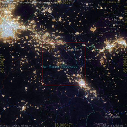
Analysis of San Marcos Tlacoyalco night lights 2016
Square area 10x10 km:
 0%
0%90-99
0%80-89
1.65%70-79
1.65%60-69
4.34%50-59
3.1%40-49
3.51%30-39
5.37%20-29
1.65%10-19
12.6%0-9
66.12%Square area 50x50 km:
0.68%90-99
0.88%80-89
1.65%70-79
1.36%60-69
2.79%50-59
1.76%40-49
2.86%30-39
3.1%20-29
3.6%10-19
7.83%0-9
73.49%Clear (daylight) street map image can be seen on geolist.org.
Map coordinates:
19° 20' 19.2" North, 98° 18' 24" West
18° 40' 26" North, 97° 36' 12.7" West
18° 0' 23.3" North, 96° 54' 1.5" West
Some cities around San Marcos Tlacoyalco sort by population:
• Magdalena Cuayucatepec
18.6 km =11.6 mi,  137°
137°
• Tlacotepec
5.6 km =3.5 mi,  279°
279°
• Cuacnopalan
18.7 km =11.6 mi,  31°
31°
• Yehualtepec
14.8 km =9.2 mi,  335°
335°
• Santa María la Alta
10 km =6.2 mi,  214°
214°
• San Gabriel Tetzoyocán
14 km =8.7 mi,  311°
311°
• Chapulco
21.6 km =13.4 mi,  104°
104°
• Xochitlan Todos Santos
18.5 km =11.5 mi, 280°
3518439 (p: 9,881)
Sources (retrieved 2019-11-25):
» Earth at Night: Flat Maps 2012, 2016