Chapulco night lights from space
Night Light of Chapulco (Puebla) from space (Mexico) Src. Average luminocity for 10x10km area is 8.2748% and for 50x50km: 10.8463%.
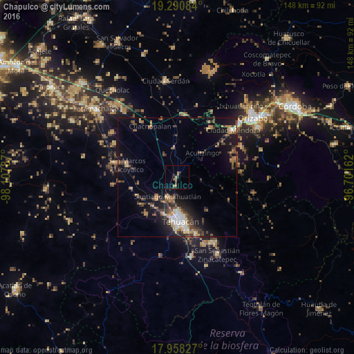
Analysis of Chapulco night lights 2016
Square area 10x10 km:
 0%
0%90-99
0%80-89
0.83%70-79
2.48%60-69
2.07%50-59
1.65%40-49
1.24%30-39
0.83%20-29
2.89%10-19
0.62%0-9
87.4%Square area 50x50 km:
0.79%90-99
0.94%80-89
1.35%70-79
1.32%60-69
2.04%50-59
1.5%40-49
2.54%30-39
2.06%20-29
2.83%10-19
8.04%0-9
76.58%Clear (daylight) street map image can be seen on geolist.org.
Map coordinates:
19° 17' 27" North, 98° 6' 28.3" West
18° 37' 33.1" North, 97° 24' 17.1" West
17° 57' 29.8" North, 96° 42' 5.8" West
Some cities around Chapulco sort by population:
• Tehuacán
18 km =11.2 mi,  177°
177°
• Miahuatlán
9.2 km =5.7 mi,  203°
203°
• Maltrata
24.7 km =15.3 mi,  33°
33°
• San Marcos Tlacoyalco
21.6 km =13.4 mi,  284°
284°
• Magdalena Cuayucatepec
11.9 km =7.4 mi,  224°
224°
• Cuacnopalan
24.1 km =15 mi,  332°
332°
• Acultzingo
14.8 km =9.2 mi,  45°
45°
• Teontepec
19.9 km =12.4 mi, 221°
3818819 (p: 5,358)
Sources (retrieved 2019-11-25):
» Earth at Night: Flat Maps 2012, 2016