Acultzingo night lights from space
Night Light of Acultzingo (Veracruz) from space (Mexico) Src. Average luminocity for 10x10km area is 2.2252% and for 50x50km: 11.6012%.
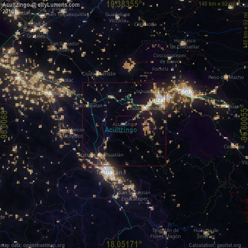
Analysis of Acultzingo night lights 2016
Square area 10x10 km:
 0%
0%90-99
0%80-89
0%70-79
0%60-69
0.83%50-59
0%40-49
2.27%30-39
0.21%20-29
0%10-19
0.41%0-9
96.28%Square area 50x50 km:
0.7%90-99
1.04%80-89
1.06%70-79
1.34%60-69
2.64%50-59
1.59%40-49
3.21%30-39
2.41%20-29
3.14%10-19
9.08%0-9
73.79%Clear (daylight) street map image can be seen on geolist.org.
Map coordinates:
19° 23' 0.8" North, 98° 0' 24.5" West
18° 43' 8.2" North, 97° 18' 13.2" West
18° 3' 6.2" North, 96° 36' 2" West
Some cities around Acultzingo sort by population:
• Río Blanco
19.9 km =12.4 mi,  51°
51°
• Ciudad Mendoza
16.4 km =10.2 mi, 53°
• Nogales
19.1 km =11.9 mi, 50°
• Miahuatlán
23.6 km =14.7 mi,  217°
217°
• Maltrata
10.7 km =6.6 mi,  16°
16°
• Cuacnopalan
24.4 km =15.2 mi,  296°
296°
• Esperanza
17.3 km =10.7 mi,  333°
333°
• Chapulco
14.8 km =9.2 mi,  225°
225°
3533376 (p: 7,040)
Sources (retrieved 2019-11-25):
» Earth at Night: Flat Maps 2012, 2016