Los Ruiseñores night lights from space
Night Light of Los Ruiseñores (Jalisco) from space (Mexico) Src. Average luminocity for 10x10km area is 25.1723% and for 50x50km: 14.5121%.
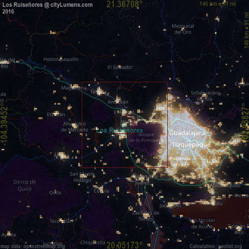
Analysis of Los Ruiseñores night lights 2016
Square area 10x10 km:
 1.14%
1.14%90-99
3.22%80-89
5.68%70-79
2.08%60-69
1.89%50-59
3.6%40-49
3.41%30-39
3.41%20-29
4.55%10-19
47.73%0-9
23.3%Square area 50x50 km:
1.65%90-99
2.09%80-89
2.85%70-79
2.29%60-69
1.46%50-59
1.47%40-49
2.24%30-39
2.11%20-29
3.4%10-19
8.42%0-9
72.01%Clear (daylight) street map image can be seen on geolist.org.
Map coordinates:
21° 22' 1.5" North, 104° 23' 40.3" West
20° 42' 39" North, 103° 41' 29" West
20° 3' 6.2" North, 102° 59' 17.8" West
Some cities around Los Ruiseñores sort by population:
• Tesistán
25.1 km =15.6 mi,  66°
66°
• Tala
6.4 km =4 mi,  188°
188°
• Tequila
24.3 km =15.1 mi,  321°
321°
• Nuevo México
26.3 km =16.3 mi,  78°
78°
• El Arenal
7.2 km =4.5 mi,  358°
358°
• Amatitán
14.3 km =8.9 mi,  343°
343°
• El Refugio
6.6 km =4.1 mi,  228°
228°
• La Venta del Astillero
15.3 km =9.5 mi, 82°
8858193 (p: 7,493)
Sources (retrieved 2019-11-25):
» Earth at Night: Flat Maps 2012, 2016