Amatitán night lights from space
Night Light of Amatitán (Jalisco) from space (Mexico) Src. Average luminocity for 10x10km area is 9.3988% and for 50x50km: 7.4053%.
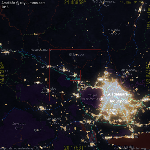
Analysis of Amatitán night lights 2016
Square area 10x10 km:
 0%
0%90-99
0.4%80-89
3.37%70-79
0.99%60-69
1.59%50-59
0%40-49
1.39%30-39
1.79%20-29
0.79%10-19
0%0-9
89.68%Square area 50x50 km:
0.34%90-99
0.52%80-89
1.41%70-79
1.13%60-69
0.85%50-59
0.62%40-49
1.6%30-39
1.45%20-29
2.11%10-19
6.68%0-9
83.3%Clear (daylight) street map image can be seen on geolist.org.
Map coordinates:
21° 29' 22.5" North, 104° 26' 2" West
20° 50' 2" North, 103° 43' 50.7" West
20° 10' 31.1" North, 103° 1' 39.5" West
Some cities around Amatitán sort by population:
• Tesistán
27.4 km =17 mi,  97°
97°
• Tala
20.3 km =12.6 mi,  171°
171°
• Tequila
12.2 km =7.6 mi,  296°
296°
• Magdalena
27 km =16.8 mi,  287°
287°
• El Arenal
7.6 km =4.7 mi,  149°
149°
• Los Ruiseñores
14.3 km =8.9 mi,  163°
163°
• El Refugio
18.1 km =11.2 mi,  182°
182°
• La Venta del Astillero
22.6 km =14 mi,  121°
121°
4018597 (p: 11,006)
Sources (retrieved 2019-11-25):
» Earth at Night: Flat Maps 2012, 2016