El Refugio night lights from space
Night Light of El Refugio (Jalisco) from space (Mexico) Src. Average luminocity for 10x10km area is 26.7045% and for 50x50km: 9.6119%.
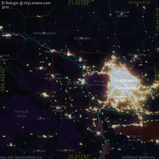
Analysis of El Refugio night lights 2016
Square area 10x10 km:
 3.22%
3.22%90-99
4.73%80-89
6.44%70-79
3.79%60-69
0.76%50-59
2.08%40-49
3.6%30-39
2.84%20-29
3.41%10-19
27.65%0-9
41.48%Square area 50x50 km:
0.34%90-99
0.53%80-89
1.94%70-79
1.63%60-69
1.07%50-59
0.81%40-49
1.76%30-39
1.78%20-29
3.32%10-19
8.78%0-9
78.04%Clear (daylight) street map image can be seen on geolist.org.
Map coordinates:
21° 19' 40.2" North, 104° 26' 32.7" West
20° 40' 17" North, 103° 44' 21.4" West
20° 0' 43.7" North, 103° 2' 10.2" West
Some cities around El Refugio sort by population:
• Tala
4.5 km =2.8 mi,  116°
116°
• Tequila
25.5 km =15.8 mi,  336°
336°
• Ahualulco de Mercado
24.7 km =15.3 mi,  277°
277°
• El Arenal
12.5 km =7.8 mi,  22°
22°
• Amatitán
18.1 km =11.2 mi,  2°
2°
• Los Ruiseñores
6.6 km =4.1 mi,  48°
48°
• Bellavista
28.4 km =17.6 mi,  158°
158°
• La Venta del Astillero
21.2 km =13.2 mi,  72°
72°
4008080 (p: 6,262)
Sources (retrieved 2019-11-25):
» Earth at Night: Flat Maps 2012, 2016