Las Palmas night lights from space
Night Light of Las Palmas (Baja California Sur) from space (Mexico) Src. Average luminocity for 10x10km area is 46.1944% and for 50x50km: 6.886%.
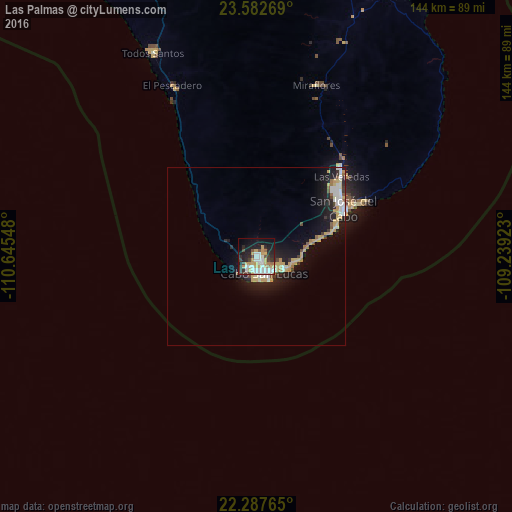
Analysis of Las Palmas night lights 2016
Square area 10x10 km:
 11.71%
90-99
7.74%80-89
4.96%70-79
11.71%60-69
1.79%50-59
2.98%40-49
3.77%30-39
7.14%20-29
12.1%10-19
23.81%0-9
12.3%Square area 50x50 km:
1.17%90-99
0.94%80-89
0.93%70-79
1.65%60-69
0.34%50-59
0.53%40-49
0.44%30-39
0.73%20-29
1.82%10-19
5.88%0-9
85.57%Clear (daylight) street map image can be seen on geolist.org.
Map coordinates:
23° 34' 57.7" North, 110° 38' 43.7" West
22° 56' 12.2" North, 109° 56' 32.5" West
22° 17' 15.5" North, 109° 14' 21.2" West
Some cities around Las Palmas sort by population:
• La Paz
139.2 km =86.5 mi,  344°
344°
• San José del Cabo
28.5 km =17.7 mi,  61°
61°
• Cabo San Lucas
5.9 km =3.7 mi,  148°
148°
• Colonia del Sol
3.1 km =1.9 mi, 148°
• Ciudad Constitución
291.2 km =180.9 mi,  323°
323°
• Las Veredas
33.9 km =21.1 mi,  45°
45°
• Puerto San Carlos
301.3 km =187.2 mi,  313°
313°
• Todos Santos
63.6 km =39.5 mi,  333°
333°
8858141 (p: 11,562)
Sources (retrieved 2019-11-25):
» Earth at Night: Flat Maps 2012, 2016