Lampazos de Naranjo night lights from space
Night Light of Lampazos de Naranjo (Nuevo León) from space (Mexico) Src. Average luminocity for 10x10km area is 6.9385% and for 50x50km: 0.3718%.
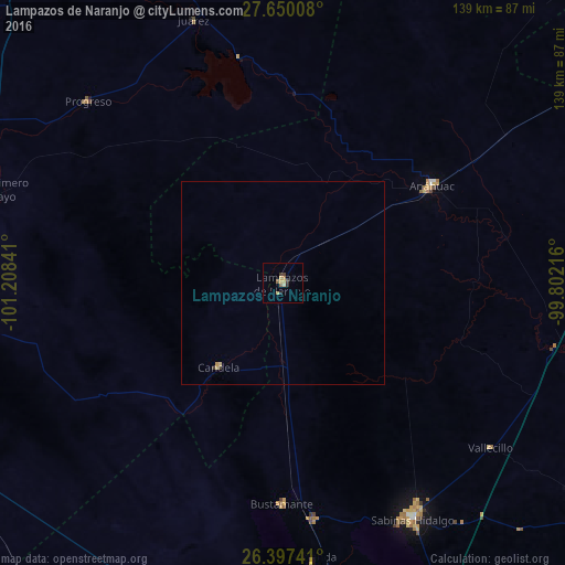
Analysis of Lampazos de Naranjo night lights 2016
Square area 10x10 km:
 0%
0%90-99
0%80-89
2.18%70-79
1.79%60-69
0.79%50-59
1.59%40-49
0.6%30-39
2.18%20-29
1.19%10-19
0%0-9
89.68%Square area 50x50 km:
0%90-99
0%80-89
0.14%70-79
0.1%60-69
0.03%50-59
0.06%40-49
0.02%30-39
0.14%20-29
0.05%10-19
0%0-9
99.46%Clear (daylight) street map image can be seen on geolist.org.
Map coordinates:
27° 39' 0.3" North, 101° 12' 30.3" West
27° 1' 31.8" North, 100° 30' 19" West
26° 23' 50.7" North, 99° 48' 7.8" West
Some cities around Lampazos de Naranjo sort by population:
• Monclova
91.7 km =57 mi,  261°
261°
• Frontera
94.4 km =58.7 mi, 263°
• Ciudad Sabinas Hidalgo
66.3 km =41.2 mi,  151°
151°
• Castaños
95.6 km =59.4 mi,  254°
254°
• San Buenaventura
103.4 km =64.2 mi,  272°
272°
• Anáhuac
44.2 km =27.5 mi,  56°
56°
• Minas de Barroterán
103.6 km =64.4 mi,  312°
312°
• El Campanario y Oradel
100.7 km =62.6 mi, 60°
4001240 (p: 5,026)
Sources (retrieved 2019-11-25):
» Earth at Night: Flat Maps 2012, 2016