La Mira night lights from space
Night Light of La Mira (Michoacán) from space (Mexico) Src. Average luminocity for 10x10km area is 15.3701% and for 50x50km: 5.8011%.
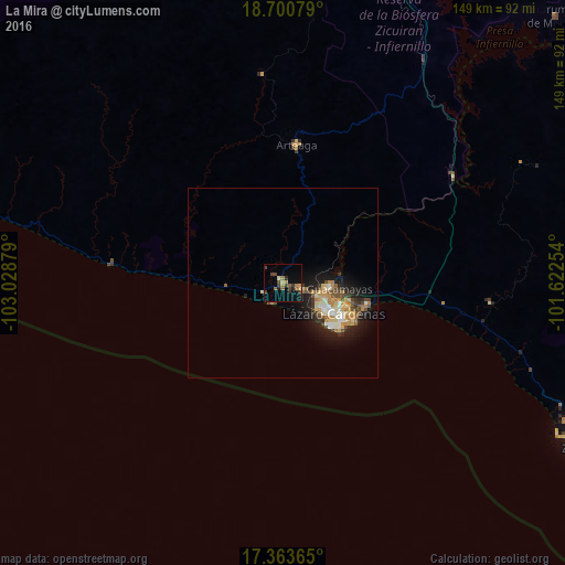
Analysis of La Mira night lights 2016
Square area 10x10 km:
 0%
0%90-99
0.65%80-89
0.22%70-79
4.33%60-69
2.38%50-59
2.81%40-49
5.84%30-39
3.03%20-29
2.38%10-19
7.36%0-9
71%Square area 50x50 km:
0.48%90-99
0.84%80-89
0.89%70-79
1.05%60-69
0.89%50-59
0.61%40-49
1.16%30-39
0.71%20-29
1.16%10-19
4.29%0-9
87.93%Clear (daylight) street map image can be seen on geolist.org.
Map coordinates:
18° 42' 2.8" North, 103° 1' 43.6" West
18° 2' 0.6" North, 102° 19' 32.4" West
17° 21' 49.1" North, 101° 37' 21.1" West
Some cities around La Mira sort by population:
• Ciudad Lázaro Cárdenas
13.1 km =8.1 mi,  122°
122°
• Guacamayas
12.1 km =7.5 mi,  97°
97°
• La Orilla
11.2 km =7 mi,  111°
111°
• Arteaga
36.2 km =22.5 mi,  5°
5°
• Buenos Aires
4.3 km =2.7 mi, 103°
• Ixtapa
83 km =51.6 mi, 119°
• Aguililla
92.3 km =57.4 mi,  327°
327°
• San José Ixtapa (Barrio Viejo)
83.3 km =51.8 mi, 116°
4026074 (p: 13,415)
Sources (retrieved 2019-11-25):
» Earth at Night: Flat Maps 2012, 2016