Ixtapa night lights from space
Night Light of Ixtapa (Guerrero) from space (Mexico) Src. Average luminocity for 10x10km area is 16.7583% and for 50x50km: 2.835%.
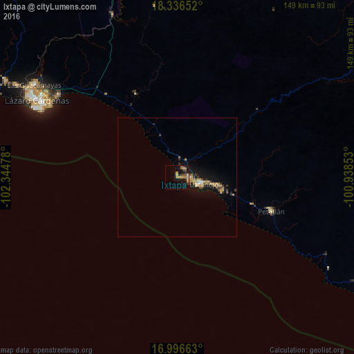
Analysis of Ixtapa night lights 2016
Square area 10x10 km:
 0%
0%90-99
0.21%80-89
4.75%70-79
3.93%60-69
3.51%50-59
0.21%40-49
4.13%30-39
0.62%20-29
4.55%10-19
16.94%0-9
61.16%Square area 50x50 km:
0.06%90-99
0.16%80-89
0.54%70-79
0.69%60-69
0.41%50-59
0.24%40-49
0.52%30-39
0.32%20-29
0.41%10-19
3.08%0-9
93.58%Clear (daylight) street map image can be seen on geolist.org.
Map coordinates:
18° 20' 11.5" North, 102° 20' 41.2" West
17° 40' 4.2" North, 101° 38' 29.9" West
16° 59' 47.9" North, 100° 56' 18.7" West
Some cities around Ixtapa sort by population:
• Ciudad Lázaro Cárdenas
70 km =43.5 mi,  298°
298°
• Guacamayas
71.9 km =44.7 mi, 302°
• Petatlán
42.2 km =26.2 mi,  110°
110°
• La Orilla
71.9 km =44.7 mi, 300°
• Buenos Aires
78.9 km =49 mi, 300°
• San José Ixtapa (Barrio Viejo)
4.5 km =2.8 mi,  31°
31°
• El Coacoyul
17.9 km =11.1 mi,  100°
100°
• San Jeronimito
33.3 km =20.7 mi, 109°
4004294 (p: 8,992)
Sources (retrieved 2019-11-25):
» Earth at Night: Flat Maps 2012, 2016