Jonuta night lights from space
Night Light of Jonuta (Tabasco) from space (Mexico) Src. Average luminocity for 10x10km area is 5.3528% and for 50x50km: 0.6986%.
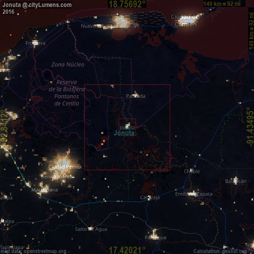
Analysis of Jonuta night lights 2016
Square area 10x10 km:
 0%
0%90-99
1.73%80-89
0.87%70-79
0%60-69
0.87%50-59
1.73%40-49
1.3%30-39
0.43%20-29
0%10-19
0%0-9
93.07%Square area 50x50 km:
0%90-99
0.2%80-89
0.06%70-79
0.07%60-69
0.09%50-59
0.1%40-49
0.25%30-39
0.17%20-29
0.07%10-19
0%0-9
98.98%Clear (daylight) street map image can be seen on geolist.org.
Map coordinates:
18° 45' 24.9" North, 92° 50' 28.3" West
18° 5' 23.4" North, 92° 8' 17.1" West
17° 25' 12.8" North, 91° 26' 5.8" West
Some cities around Jonuta sort by population:
• Palenque
66.6 km =41.4 mi,  165°
165°
• Macuspana
60.7 km =37.7 mi,  232°
232°
• Emiliano Zapata
55.3 km =34.4 mi,  134°
134°
• San Carlos
50.3 km =31.3 mi,  235°
235°
• Belén
60.2 km =37.4 mi, 236°
• Ciudad Pemex
43.2 km =26.8 mi, 237°
• La Curva
44.6 km =27.7 mi, 236°
• Salto de Agua
63.2 km =39.3 mi,  199°
199°
3526453 (p: 6,899)
Sources (retrieved 2019-11-25):
» Earth at Night: Flat Maps 2012, 2016