Ciudad Pemex night lights from space
Night Light of Ciudad Pemex (Tabasco) from space (Mexico) Src. Average luminocity for 10x10km area is 80.9437% and for 50x50km: 10.4146%.
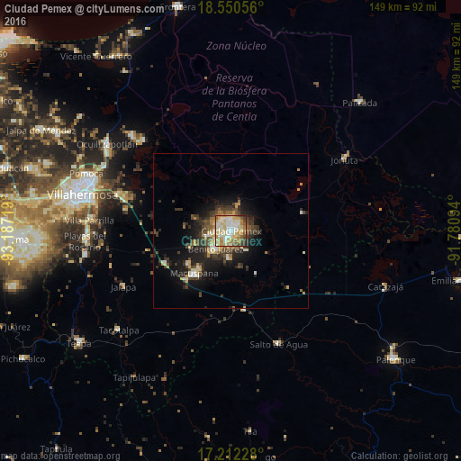
Analysis of Ciudad Pemex night lights 2016
Square area 10x10 km:
 12.34%
90-99
30.52%80-89
21.65%70-79
11.26%60-69
7.79%50-59
8.01%40-49
4.98%30-39
2.81%20-29
0.65%10-19
0%0-9
0%Square area 50x50 km:
0.65%90-99
2%80-89
1.56%70-79
1.36%60-69
1.01%50-59
1%40-49
2.3%30-39
2.71%20-29
3.02%10-19
6.75%0-9
77.66%Clear (daylight) street map image can be seen on geolist.org.
Map coordinates:
18° 33' 2" North, 93° 11' 13.9" West
17° 52' 57.6" North, 92° 29' 2.6" West
17° 12' 44.2" North, 91° 46' 51.4" West
Some cities around Ciudad Pemex sort by population:
• Macuspana
18 km =11.2 mi,  220°
220°
• Río de Teapa
45.4 km =28.2 mi,  255°
255°
• San Carlos
7.3 km =4.5 mi, 221°
• Tamulte de las Sabanas
44.3 km =27.5 mi,  314°
314°
• Jonuta
43.2 km =26.8 mi,  57°
57°
• Belén
17 km =10.6 mi,  232°
232°
• La Curva
1.9 km =1.2 mi,  193°
193°
• Salto de Agua
39.6 km =24.6 mi,  157°
157°
3530588 (p: 5,822)
Sources (retrieved 2019-11-25):
» Earth at Night: Flat Maps 2012, 2016