La Curva night lights from space
Night Light of La Curva (Tabasco) from space (Mexico) Src. Average luminocity for 10x10km area is 79.0952% and for 50x50km: 10.5639%.
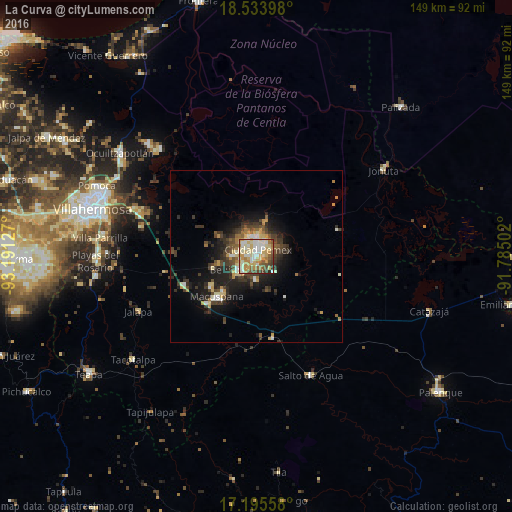
Analysis of La Curva night lights 2016
Square area 10x10 km:
 11.26%
90-99
29.87%80-89
19.48%70-79
12.12%60-69
7.36%50-59
8.01%40-49
7.58%30-39
3.46%20-29
0.87%10-19
0%0-9
0%Square area 50x50 km:
0.66%90-99
2.02%80-89
1.6%70-79
1.37%60-69
1.01%50-59
1.03%40-49
2.3%30-39
2.78%20-29
3.05%10-19
6.83%0-9
77.35%Clear (daylight) street map image can be seen on geolist.org.
Map coordinates:
18° 32' 2.3" North, 93° 11' 28.6" West
17° 51' 57.7" North, 92° 29' 17.3" West
17° 11' 44.1" North, 91° 47' 6.1" West
Some cities around La Curva sort by population:
• Macuspana
16.3 km =10.1 mi,  224°
224°
• Río de Teapa
44.6 km =27.7 mi,  258°
258°
• San Carlos
5.7 km =3.5 mi,  230°
230°
• Jonuta
44.6 km =27.7 mi,  56°
56°
• Belén
15.6 km =9.7 mi,  236°
236°
• Ciudad Pemex
1.9 km =1.2 mi,  13°
13°
• Huapinol
45.2 km =28.1 mi,  278°
278°
• Salto de Agua
38.1 km =23.7 mi,  155°
155°
3802806 (p: 5,651)
Sources (retrieved 2019-11-25):
» Earth at Night: Flat Maps 2012, 2016