Jiquílpan de Juárez night lights from space
Night Light of Jiquílpan de Juárez (Michoacán) from space (Mexico) Src. Average luminocity for 10x10km area is 25.5159% and for 50x50km: 4.0557%.

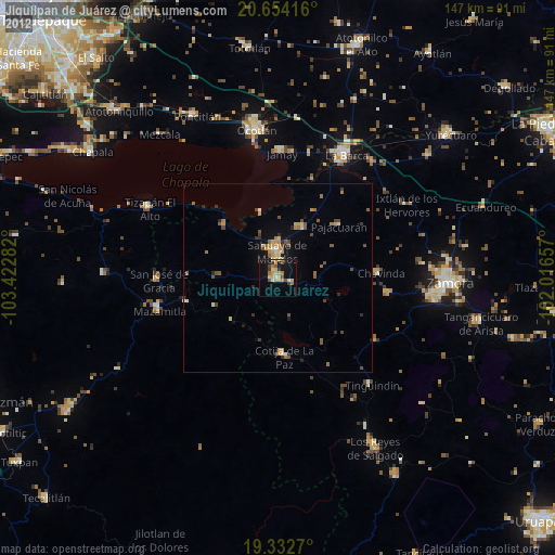
Analysis of Jiquílpan de Juárez night lights 2016
Square area 10x10 km:
 0.6%
0.6%90-99
0.99%80-89
5.75%70-79
5.16%60-69
6.55%50-59
3.97%40-49
0%30-39
2.98%20-29
6.15%10-19
32.14%0-9
35.71%Square area 50x50 km:
0.1%90-99
0.24%80-89
0.82%70-79
0.7%60-69
0.58%50-59
0.52%40-49
0.81%30-39
0.77%20-29
0.69%10-19
3.05%0-9
91.71%Clear (daylight) street map image can be seen on geolist.org.
Map coordinates:
20° 39' 15" North, 103° 25' 22.2" West
19° 59' 41.4" North, 102° 43' 10.9" West
19° 19' 57.7" North, 102° 0' 59.7" West
Some cities around Jiquílpan de Juárez sort by population:
• Sahuayo de Morelos
7.1 km =4.4 mi,  3°
3°
• Cotija de la Paz
20.7 km =12.9 mi,  174°
174°
• Venustiano Carranza
15.1 km =9.4 mi,  27°
27°
• Santiago Tangamandapio
30 km =18.6 mi,  98°
98°
• Pajacuarán
21.2 km =13.2 mi,  49°
49°
• Tarécuato
31.5 km =19.6 mi,  122°
122°
• Cojumatlán de Régules
19.5 km =12.1 mi,  314°
314°
• Chavinda
27.1 km =16.8 mi,  87°
87°
4003923 (p: 24,233)
Sources (retrieved 2019-11-25):
» Earth at Night: Flat Maps 2012, 2016